Difference between revisions of "2009-09-03 39 -104"
From Geohashing
imported>Cedarm (New page: {{subst:Expedition |lat = 39 |lon = -104 |date = 2009-09-03 }}) |
imported>Cedarm |
||
| Line 1: | Line 1: | ||
| − | |||
| − | |||
| − | |||
| − | |||
| − | |||
{{meetup graticule | {{meetup graticule | ||
| lat=39 | | lat=39 | ||
| lon=-104 | | lon=-104 | ||
| date=2009-09-03 | | date=2009-09-03 | ||
| + | | graticule_name=Denver, Colorado | ||
| + | | graticule_link=Denver, Colorado | ||
}} | }} | ||
| Line 13: | Line 10: | ||
__NOTOC__ | __NOTOC__ | ||
== Location == | == Location == | ||
| − | + | Unused land. | |
== Participants == | == Participants == | ||
| − | + | [[User:CedarM | Cedar Myers]] | |
== Plans == | == Plans == | ||
| − | + | Another whim after work. | |
== Expedition == | == Expedition == | ||
| + | Ok, note to self: Don't plow across a field in sandals. | ||
| − | + | This location is relatively boring right now. Unused land, for sale. Just watch out for the attack plants... | |
| − | |||
| − | |||
== Photos == | == Photos == | ||
| − | |||
| − | |||
| − | |||
| − | |||
| − | |||
| − | |||
<gallery perrow="3"> | <gallery perrow="3"> | ||
| − | + | Image:2009-09-03 39 -104 sign.JPG | For sale | |
| + | Image:2009-09-03 39 -104 gps.JPG | GPS | ||
| + | Image:2009-09-03 39 -104 me.JPG | Stupid grin | ||
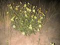
| + | Image:2009-09-03 39 -104 bush.JPG | The local plants | ||
| + | Image:2009-09-03 39 -104 hashpoint.JPG | Hash point | ||
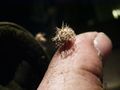
| + | Image:2009-09-03 39 -104 attack.JPG | Attack plants | ||
| + | Image:2009-09-03 39 -104 gotme.JPG | AHHH! | ||
| + | Image:2009-09-03 39 -104 gotmegood.JPG | Ok, it doesn't look that bad, but pulling it out really hurt! | ||
</gallery> | </gallery> | ||
| − | |||
| − | |||
| − | |||
| − | |||
| − | |||
| − | |||
| − | |||
[[Category:Expeditions]] | [[Category:Expeditions]] | ||
| − | |||
[[Category:Expeditions with photos]] | [[Category:Expeditions with photos]] | ||
| − | |||
| − | |||
| − | |||
| − | |||
| − | |||
[[Category:Coordinates reached]] | [[Category:Coordinates reached]] | ||
| − | |||
| − | |||
| − | |||
| − | |||
| − | |||
| − | |||
| − | |||
| − | |||
| − | |||
| − | |||
Revision as of 20:09, 8 September 2009
| Thu 3 Sep 2009 in Denver, Colorado: 39.7915021, -104.7703814 geohashing.info google osm bing/os kml crox |
Location
Unused land.
Participants
Plans
Another whim after work.
Expedition
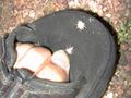
Ok, note to self: Don't plow across a field in sandals.
This location is relatively boring right now. Unused land, for sale. Just watch out for the attack plants...
Photos
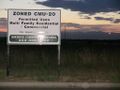
For sale
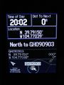
GPS

Stupid grin
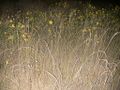
The local plants
Hash point
Attack plants
AHHH!
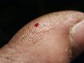
Ok, it doesn't look that bad, but pulling it out really hurt!


