Difference between revisions of "2009-09-15 39 -111"
From Geohashing
imported>GarafaJon (→Location) |
imported>Benjw (removing unused bits of expedition template) |
||
| Line 1: | Line 1: | ||
| − | |||
| − | |||
| − | |||
| − | |||
{{meetup graticule | {{meetup graticule | ||
| lat=39 | | lat=39 | ||
| Line 8: | Line 4: | ||
| date=2009-09-15 | | date=2009-09-15 | ||
}} | }} | ||
| − | |||
| − | |||
| − | |||
== Location == | == Location == | ||
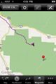
Up on a really cool ridge in the Uinta mountains, south of Provo, Utah. About 9,300 ft. | Up on a really cool ridge in the Uinta mountains, south of Provo, Utah. About 9,300 ft. | ||
== Participants == | == Participants == | ||
| − | [[User:GarafaJon|GarafaJon]] drove. | + | * [[User:GarafaJon|GarafaJon]] drove. |
| − | [[User:SaraJane|SaraJane]] posed. | + | * [[User:SaraJane|SaraJane]] posed. |
| − | [[User:Spencer|Spencer]] took the pictures. | + | * [[User:Spencer|Spencer]] took the pictures. |
| − | |||
| − | |||
| − | |||
| − | |||
| − | |||
| − | |||
| − | |||
| − | |||
| − | |||
== Photos == | == Photos == | ||
| − | |||
| − | |||
| − | |||
| − | |||
| − | |||
| − | |||
<gallery perrow="3"> | <gallery perrow="3"> | ||
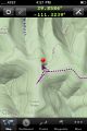
Image:2009-09-15 39 -111 track1.jpg | On our way | Image:2009-09-15 39 -111 track1.jpg | On our way | ||
| Line 40: | Line 18: | ||
Image:2009-09-15_39_-111_Sara_Hashing.jpg | SaraJane at the geohash! | Image:2009-09-15_39_-111_Sara_Hashing.jpg | SaraJane at the geohash! | ||
</gallery> | </gallery> | ||
| + | |||
| + | == Ribbons == | ||
| + | {{Virgin graticule | latitude = 39 | longitude = -111 | date = 2009-09-15 | name = SaraJane }} | ||
[[Category:Expeditions with photos]] | [[Category:Expeditions with photos]] | ||
[[Category:Coordinates reached]] | [[Category:Coordinates reached]] | ||
| − | |||
| − | |||
| − | |||
| − | |||
| − | |||
| − | |||
| − | |||
| − | |||
| − | |||
[[Category:Expeditions]] | [[Category:Expeditions]] | ||
| − | |||
| − | |||
| − | |||
| − | |||
| − | |||
| − | |||
| − | |||
| − | |||
| − | |||
| − | |||
| − | |||
| − | |||
| − | |||
| − | |||
| − | |||
| − | |||
| − | |||
| − | |||
| − | |||
| − | |||
| − | |||
Revision as of 11:03, 24 August 2010
| Tue 15 Sep 2009 in 39,-111: 39.8586751, -111.3238955 geohashing.info google osm bing/os kml crox |
Contents
Location
Up on a really cool ridge in the Uinta mountains, south of Provo, Utah. About 9,300 ft.
Participants
Photos
On our way
There!
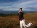
SaraJane at the geohash!


