Difference between revisions of "2009-09-29 51 -0"
imported>Davidc (writeup) |
imported>Davidc (adding photos. done!) |
||
| Line 28: | Line 28: | ||
So back to the car, south across the M25 and to a car park by the Yehudi Menuhin school. England's countryside is briliantly made accessible by a network of public rights of way, by which farmers are forced to allow the public to pass across their land. So through a farm I went, past a field of horses, and through a foreboding tunnel under the M25 to reach the hashfield. | So back to the car, south across the M25 and to a car park by the Yehudi Menuhin school. England's countryside is briliantly made accessible by a network of public rights of way, by which farmers are forced to allow the public to pass across their land. So through a farm I went, past a field of horses, and through a foreboding tunnel under the M25 to reach the hashfield. | ||
| − | But alas, it was not to be. The | + | But alas, it was not to be. The field was full of hash-horses and guarded by an electric hash-fence, and there was no public footpath across it. Not knowing how friendly the horses - or their owners - would be if I jumped the fence, I regretfully left the field and chalked it up as my first "Did not reach - no public access". |
I estimate I got within 50m of the hashpoint from the north, but only 250m from the south. | I estimate I got within 50m of the hashpoint from the north, but only 250m from the south. | ||
| Line 36: | Line 36: | ||
== Photos == | == Photos == | ||
| − | <!-- | + | <gallery perrow="4"> |
| − | + | Image:2009-09-29_51_-0_IMG_1663.JPG|School 1 | |
| − | Image:2009- | + | Image:2009-09-29_51_-0_IMG_1654.JPG|School church |
| − | Image:2009- | + | Image:2009-09-29_51_-0_IMG_1658.JPG|A river separated me from the hashpoint to the north. |
| − | -- | + | Image:2009-09-29_51_-0_IMG_1667.JPG|School 2 |
| − | + | Image:2009-09-29_51_-0_IMG_1668.JPG|A public footpath! Barely a track through the woods. | |
| − | + | Image:2009-09-29_51_-0_IMG_1671.JPG|Keep going. We are not the hash-horses you are looking for. | |
| + | Image:2009-09-29_51_-0_IMG_1673.JPG|The M25 and a tunnel. | ||
| + | Image:2009-09-29_51_-0_IMG_1674.JPG|The hash-light at the end of the tunnel. | ||
| + | Image:2009-09-29_51_-0_IMG_1677.JPG|Bzzt. Bzzt. Bzzt. I am often tempted to wee on one of these. | ||
| + | Image:2009-09-29_51_-0_IMG_1679.JPG|I am the Guardian of the Hash. | ||
| + | Image:2009-09-29_51_-0_IMG_1681.JPG|Look at us galloping to the hashpoint. Nyer! | ||
| + | Image:2009-09-29_51_-0_IMG_1683.JPG|As close as I could get. | ||
| + | Image:2009-09-29_51_-0_IMG_1685.JPG|My selfish need for a grazing field may have denied you a hash, but I would still like to be your friend. | ||
| + | Image:2009-09-29_51_-0_IMG_1687.JPG|The hashpoint is approximately at the metal feeding bin in the distance. | ||
| + | Image:2009-09-29_51_-0_IMG_1689.JPG|Even blindfolded, hash-horses can smell your GPS, | ||
| + | Image:2009-09-29_51_-0_IMG_1694.JPG|Silly frown. Onward! | ||
</gallery> | </gallery> | ||
| Line 48: | Line 58: | ||
[[Category:Expeditions]] | [[Category:Expeditions]] | ||
[[Category:Expeditions with photos]] | [[Category:Expeditions with photos]] | ||
| − | + | [[Category:Coordinates not reached]] | |
[[Category:Not reached - No public access]] | [[Category:Not reached - No public access]] | ||
Revision as of 21:18, 30 September 2009
| Tue 29 Sep 2009 in 51,-0: 51.3119654, -0.3847330 geohashing.info google osm bing/os kml crox |
Location
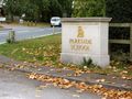
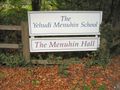
A field right by the M25, between Parkside School and the Yehudi Menuhin School in Stoke D'Abernam.
Participants
Plans
I did not post plans here as I was attempting several hashes on the day, and would not have been able to arrange a meetup time.
Expedition
Right. After a few days faffing around with nonstop work, I decided it was time for the hashing to begin in earnest. Although my iPhone was in for servicing, I had a TomTom and a 3G card for satellite maps, so I figured I could get close enough to any hashes I sought. I had a vague plan to head towards Wales, since I never really explored it and I've recently developed a fetish for the Welsh accent, so I started off in 51,-0 with this hash.
I left home just after hash o'clock, around 15:00, and it was a short 15 mile drive to the hash area. Looking at the satellite map, I could see the hash-field was bordered on the north by a river, and on the south by the M25 motorway (London's main ring road). Although I could see a tunnel under the M25, this route was rather longer, so I decided to try from the north instead, in the hopes of finding a bridge.
Just north of the river was Parkside School. Although I'd not been to that school before, the buildings and atmosphere evoked some strong memories of my adolescence at an English public school. I was especially amused at the warning to motorists: "CAUTION: LIVE CHILDREN". After navigating through the school to the river, I couldn't find any bridge, and a passing gardener confirmed that there was no way over.
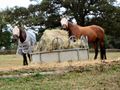
So back to the car, south across the M25 and to a car park by the Yehudi Menuhin school. England's countryside is briliantly made accessible by a network of public rights of way, by which farmers are forced to allow the public to pass across their land. So through a farm I went, past a field of horses, and through a foreboding tunnel under the M25 to reach the hashfield.
But alas, it was not to be. The field was full of hash-horses and guarded by an electric hash-fence, and there was no public footpath across it. Not knowing how friendly the horses - or their owners - would be if I jumped the fence, I regretfully left the field and chalked it up as my first "Did not reach - no public access".
I estimate I got within 50m of the hashpoint from the north, but only 250m from the south.
This geohash was part of davidc's European tour in Autumn 2009:
England:
- 2009-09-27 50 -1 - Eastleigh, Hampshire.
- 2009-09-29 51 -0 - Stoke D'Abernon, Surrey (Failed: No Public Access)
- 1978-11-27 51 -0 on 2009-09-29 - my Origin Geohash in Bramley, Surrey.
- 2009-09-29 51 -1 - Ashmansworth. Speed racer!
- 2009-09-30 52 -2 - Herefordshire. Virgin graticule!
- 2009-09-30 52 -1 - Sibford Gower, Oxfordshire.
- 2009-10-01 51 -0 - Reigate, Surrey (Failed Ambassador)
Portugal:
- 2009-10-07 38 -9 - Cabo Espichel, Sesimbra
Photos
School 1
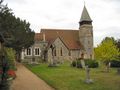
School church
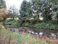
A river separated me from the hashpoint to the north.
School 2
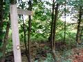
A public footpath! Barely a track through the woods.
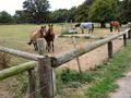
Keep going. We are not the hash-horses you are looking for.
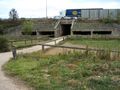
The M25 and a tunnel.
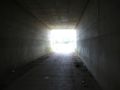
The hash-light at the end of the tunnel.
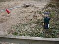
Bzzt. Bzzt. Bzzt. I am often tempted to wee on one of these.
I am the Guardian of the Hash.
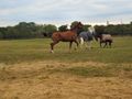
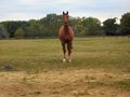
Look at us galloping to the hashpoint. Nyer!
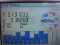
As close as I could get.

My selfish need for a grazing field may have denied you a hash, but I would still like to be your friend.

The hashpoint is approximately at the metal feeding bin in the distance.
Even blindfolded, hash-horses can smell your GPS,

Silly frown. Onward!


