Difference between revisions of "2009-10-17 50 6"
From Geohashing
imported>Teutschini (New page: <!-- If you did not specify these parameters in the template, please substitute appropriate things for IMAGE, LAT, LON, and DATE (YYYY-MM-DD format) --> <!-- [[Image:{{{image|IMAGE}}}|thum...) |
imported>Teutschini |
||
| Line 12: | Line 12: | ||
__NOTOC__ | __NOTOC__ | ||
== Location == | == Location == | ||
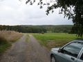
| − | + | In a forested valley between Schüller and Gönnersdorf near Jünkerath, Eifel, the hashpoint being 60m off a junction of two forest paths. | |
== Participants == | == Participants == | ||
* [[User:Teutschini|Teutschini]] | * [[User:Teutschini|Teutschini]] | ||
| + | * Marion | ||
== Plans == | == Plans == | ||
| − | |||
== Expedition == | == Expedition == | ||
| − | |||
| − | + | First geohashing with my iPhone. 20 minute walk from Jünkerath up the valley of a small creek with name unknown. It was a little difficult to get to the point itself crossing through thick undergrowth, but since it needed only 40m off the path still quite easy. iPhone wouldn't give me a more accurate position than +-17m. Well, it's no perfect GPS but better than none. | |
| − | + | And Geohashing is even more fun with someone joining you, thanks Marion for following me into the forest ;-) | |
| − | |||
| − | |||
| − | |||
| − | |||
| − | |||
== Tracklog == | == Tracklog == | ||
| Line 43: | Line 37: | ||
<gallery perrow="6"> | <gallery perrow="6"> | ||
Image:2009-10-02_50_6 01.JPG | Let's start geohashing | Image:2009-10-02_50_6 01.JPG | Let's start geohashing | ||
| − | |||
| − | |||
| − | |||
| − | |||
| − | |||
</gallery> | </gallery> | ||
Revision as of 15:31, 18 October 2009
| Sat 17 Oct 2009 in 50,6: 50.3283133, 6.5769559 geohashing.info google osm bing/os kml crox |
Location
In a forested valley between Schüller and Gönnersdorf near Jünkerath, Eifel, the hashpoint being 60m off a junction of two forest paths.
Participants
- Teutschini
- Marion
Plans
Expedition
First geohashing with my iPhone. 20 minute walk from Jünkerath up the valley of a small creek with name unknown. It was a little difficult to get to the point itself crossing through thick undergrowth, but since it needed only 40m off the path still quite easy. iPhone wouldn't give me a more accurate position than +-17m. Well, it's no perfect GPS but better than none. And Geohashing is even more fun with someone joining you, thanks Marion for following me into the forest ;-)
Tracklog
Photos
Let's start geohashing
