Difference between revisions of "2009-10-17 50 6"
From Geohashing
imported>Benjw m (→Photos: sp) |
imported>Benjw m (removing unused bits of expedition template) |
||
| Line 1: | Line 1: | ||
| − | |||
| − | |||
| − | |||
| − | |||
{{meetup graticule | {{meetup graticule | ||
| lat=50 | | lat=50 | ||
| Line 9: | Line 5: | ||
}} | }} | ||
| − | |||
__NOTOC__ | __NOTOC__ | ||
== Location == | == Location == | ||
| Line 17: | Line 12: | ||
* [[User:Teutschini|Teutschini]] | * [[User:Teutschini|Teutschini]] | ||
* Marion | * Marion | ||
| − | |||
| − | |||
== Expedition == | == Expedition == | ||
| Line 24: | Line 17: | ||
First geohashing with my iPhone. 20 minute walk from Jünkerath up the valley of a small creek with name unknown. It was a little difficult to get to the point itself crossing through thick underwood, but since it needed only 40m off the path still quite easy. iPhone wouldn't give me a more accurate position than +-17m. Well, it's no perfect GPS but better than none. | First geohashing with my iPhone. 20 minute walk from Jünkerath up the valley of a small creek with name unknown. It was a little difficult to get to the point itself crossing through thick underwood, but since it needed only 40m off the path still quite easy. iPhone wouldn't give me a more accurate position than +-17m. Well, it's no perfect GPS but better than none. | ||
And Geohashing is even more fun with someone joining you, thanks Marion for following me into the forest ;-) | And Geohashing is even more fun with someone joining you, thanks Marion for following me into the forest ;-) | ||
| − | |||
| − | |||
| − | |||
== Photos == | == Photos == | ||
| − | |||
| − | |||
| − | |||
| − | |||
| − | |||
<gallery perrow="4"> | <gallery perrow="4"> | ||
Image:2009-10-17_50_6 01.JPG | Up the valley | Image:2009-10-17_50_6 01.JPG | Up the valley | ||
| Line 48: | Line 33: | ||
[[Category:Expeditions with photos]] | [[Category:Expeditions with photos]] | ||
[[Category:Coordinates reached]] | [[Category:Coordinates reached]] | ||
| − | |||
| − | |||
| − | |||
| − | |||
| − | |||
| − | |||
[[Category:Expeditions]] | [[Category:Expeditions]] | ||
| − | |||
| − | |||
| − | |||
| − | |||
| − | |||
| − | |||
| − | |||
| − | |||
| − | |||
| − | |||
| − | |||
| − | |||
| − | |||
| − | |||
| − | |||
| − | |||
| − | |||
| − | |||
Revision as of 15:48, 30 July 2010
| Sat 17 Oct 2009 in 50,6: 50.3283133, 6.5769559 geohashing.info google osm bing/os kml crox |
Location
In a forested valley between Schüller and Gönnersdorf near Jünkerath, Eifel, the hashpoint being 60m off a junction of two forest paths.
Participants
- Teutschini
- Marion
Expedition
First geohashing with my iPhone. 20 minute walk from Jünkerath up the valley of a small creek with name unknown. It was a little difficult to get to the point itself crossing through thick underwood, but since it needed only 40m off the path still quite easy. iPhone wouldn't give me a more accurate position than +-17m. Well, it's no perfect GPS but better than none. And Geohashing is even more fun with someone joining you, thanks Marion for following me into the forest ;-)
Photos
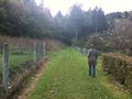
Up the valley
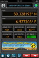
Proof
Once again perfect focus
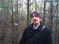
Proud geohasher
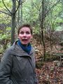
Marion's so excited
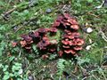
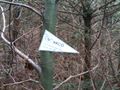
Mind the fungi!
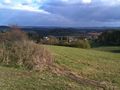
On the way back near Gönnersdorf


