Difference between revisions of "2009-10-29 52 -0"
From Geohashing
imported>Joehardflec |
imported>Joehardflec (→Photos) |
||
| Line 22: | Line 22: | ||
== Photos == | == Photos == | ||
| − | <gallery perrow=" | + | <gallery perrow="3"> |
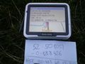
Image:2009-10-29 52 -0 GPS.jpg | Witty Comment | Image:2009-10-29 52 -0 GPS.jpg | Witty Comment | ||
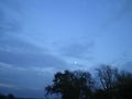
Image:2009-10-29 52 -0 Moon.jpg | Witty Comment | Image:2009-10-29 52 -0 Moon.jpg | Witty Comment | ||
Revision as of 21:44, 30 October 2009
| Thu 29 Oct 2009 in 52,-0: 52.5080515, -0.8884250 geohashing.info google osm bing/os kml crox |
Location
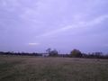
In a field where a footpath joins up with the lane 'connecting' (I doubt the bridge in the middle is passable with any vehicle, but you can do it on foot) Great Bowden with Welham.
Participants
Expedition
Joe drove to Great Bowden, drove partway up the track, before walking to the right field and finding the point.
Photos
Witty Comment
Witty Comment
Witty Comment

Witty Comment


