Difference between revisions of "2009-11-02 52 -1"
From Geohashing
imported>Kimble |
imported>Kimble |
||
| Line 19: | Line 19: | ||
[[User:kimble|Kim]] noticed the hash location was close to one of her regular cycling routes south from Birmingham. | [[User:kimble|Kim]] noticed the hash location was close to one of her regular cycling routes south from Birmingham. | ||
I set off on a slightly more direct route than usual, in an attempt to arrive at the hash while there was still a decent amount of daylight. The public footpath was easily reached by bike. I then continued down the path on foot, lifting the bike over a style to reach the hash location. Uneven ground, nettles, brambles and a heavy bike made reaching the exact location tricky, but I successfully located the hashpoint without any nettle or p*nct*re incidents. | I set off on a slightly more direct route than usual, in an attempt to arrive at the hash while there was still a decent amount of daylight. The public footpath was easily reached by bike. I then continued down the path on foot, lifting the bike over a style to reach the hash location. Uneven ground, nettles, brambles and a heavy bike made reaching the exact location tricky, but I successfully located the hashpoint without any nettle or p*nct*re incidents. | ||
| + | |||
| + | |||
| + | == Photos == | ||
| + | <gallery perrow="3"> | ||
| + | Image:20091102021.jpg | Bike at the hashpoint | ||
| + | Image:20091102019.jpg | GPS coordinates | ||
| + | Image:20091102023.jpg | Me at the point | ||
| + | </gallery> | ||
Revision as of 19:31, 2 November 2009
| Mon 2 Nov 2009 in 52,-1: 52.3487473, -1.9826228 geohashing.info google osm bing/os kml crox |
Location
Birmingham, United Kingdom (52, -1) graticule. Just off a public footpath west of Alvechurch.
Participants
Expedition
Kim noticed the hash location was close to one of her regular cycling routes south from Birmingham. I set off on a slightly more direct route than usual, in an attempt to arrive at the hash while there was still a decent amount of daylight. The public footpath was easily reached by bike. I then continued down the path on foot, lifting the bike over a style to reach the hash location. Uneven ground, nettles, brambles and a heavy bike made reaching the exact location tricky, but I successfully located the hashpoint without any nettle or p*nct*re incidents.
Photos
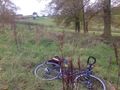
Bike at the hashpoint
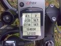
GPS coordinates

Me at the point


