Difference between revisions of "2009-11-04 -43 172"
imported>BuffyNZ (New page: {{subst:Expedition |lat = -43 |lon = 172 |date = 2009-11-04 }}) |
imported>BuffyNZ |
||
| Line 1: | Line 1: | ||
| − | |||
<!-- If you did not specify these parameters in the template, please substitute appropriate things for IMAGE, LAT, LON, and DATE (YYYY-MM-DD format) --> | <!-- If you did not specify these parameters in the template, please substitute appropriate things for IMAGE, LAT, LON, and DATE (YYYY-MM-DD format) --> | ||
<!-- | <!-- | ||
| Line 8: | Line 7: | ||
| lon=172 | | lon=172 | ||
| date=2009-11-04 | | date=2009-11-04 | ||
| + | | graticule_name=Christchurch | ||
| + | | graticule_link=Christchurch, New Zealand}} | ||
}} | }} | ||
| Line 13: | Line 14: | ||
__NOTOC__ | __NOTOC__ | ||
== Location == | == Location == | ||
| − | + | Located just south east of Rangiora and South East of Woodend, on the side of a small road that runs along a small unknown creek. | |
== Participants == | == Participants == | ||
| + | [[User:BuffyNZ: Stuart], John and Peter. | ||
| + | == Expedition == | ||
| − | == | + | === [[User::BuffyNZ]] === |
| + | I had been watching for an accessable location in my graticule for a week or so. Location and available time worked in together today. | ||
| + | Having checked out the co-ordinates using the trusty geohash iPhone app, I sent out a call to other XKCD fans in my company [[http://tait.co.nz:Tait Electronics]] to see if anyone else would be keen to join me. | ||
| − | + | Peter and John stepped up. | |
| + | We jumped into my car and headed off to the location. As using hand-held GPS units and phones in a car is now banned in New Zealand, John acted as the navigator as we set off towards Cox Road. | ||
| − | + | Cox road turned out to be a gravel road with a 'No Exit' sign. We followed it, and eventually reached out target co-ordinates. | |
== Photos == | == Photos == | ||
| − | < | + | <gallery perrow="4"> |
Insert pictures between the gallery tags using the following format: | Insert pictures between the gallery tags using the following format: | ||
| − | Image:2009- | + | Image:2009-11-04 -42 172 river.jpg | The river, nice and peaceful. |
| − | Image:2009- | + | Image:2009-11-04 -42 172 transport.jpg | Our trusty transport. |
| − | -- | + | Image:2009-11-04 -42 172 john.jpg | John, taking a photo of me with the iPhone |
| − | + | Image:2009-11-04 -42 172 screenshot.png | A screenshot of the maps application in the iPhone | |
| − | |||
</gallery> | </gallery> | ||
| − | |||
| − | |||
| − | |||
| − | |||
| − | |||
| − | |||
[[Category:Expeditions]] | [[Category:Expeditions]] | ||
| − | |||
[[Category:Expeditions with photos]] | [[Category:Expeditions with photos]] | ||
| − | |||
| − | |||
| − | |||
| − | |||
| − | |||
[[Category:Coordinates reached]] | [[Category:Coordinates reached]] | ||
| − | |||
| − | |||
| − | |||
| − | |||
| − | |||
| − | |||
| − | |||
| − | |||
| − | |||
| − | |||
Revision as of 00:54, 4 November 2009
| Wed 4 Nov 2009 in Christchurch: -43.3458224, 172.6437100 geohashing.info google osm bing/os kml crox |
}}
Location
Located just south east of Rangiora and South East of Woodend, on the side of a small road that runs along a small unknown creek.
Participants
[[User:BuffyNZ: Stuart], John and Peter.
Expedition
[[User::BuffyNZ]]
I had been watching for an accessable location in my graticule for a week or so. Location and available time worked in together today.
Having checked out the co-ordinates using the trusty geohash iPhone app, I sent out a call to other XKCD fans in my company [Electronics] to see if anyone else would be keen to join me.
Peter and John stepped up.
We jumped into my car and headed off to the location. As using hand-held GPS units and phones in a car is now banned in New Zealand, John acted as the navigator as we set off towards Cox Road.
Cox road turned out to be a gravel road with a 'No Exit' sign. We followed it, and eventually reached out target co-ordinates.
Photos
- Insert pictures between the gallery tags using the following format:
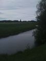
The river, nice and peaceful.
- 2009-11-04 -42 172 transport.jpg
Our trusty transport.
- 2009-11-04 -42 172 john.jpg
John, taking a photo of me with the iPhone

A screenshot of the maps application in the iPhone

