Difference between revisions of "2009-11-04 -43 172"
imported>BuffyNZ m |
imported>BuffyNZ |
||
| Line 38: | Line 38: | ||
<gallery perrow="2"> | <gallery perrow="2"> | ||
Image:2009-11-04 -42 172 river.jpg | The river, nice and peaceful. | Image:2009-11-04 -42 172 river.jpg | The river, nice and peaceful. | ||
| − | Image: | + | Image:Transport.jpg | Our trusty transport. |
Image:2009-11-04 -42 172 John.jpg | John, taking a photo of me with the iPhone | Image:2009-11-04 -42 172 John.jpg | John, taking a photo of me with the iPhone | ||
Image:2009-11-04 -42 172 screenshot.png | A screenshot of the maps application in the iPhone | Image:2009-11-04 -42 172 screenshot.png | A screenshot of the maps application in the iPhone | ||
Revision as of 01:25, 4 November 2009
| Wed 4 Nov 2009 in Christchurch: -43.3458224, 172.6437100 geohashing.info google osm bing/os kml crox |
Location
Located near Christchurch, New Zealand just south east of Rangiora and South East of Woodend, on the side of a small road that runs along a small unknown creek.
Participants
Stuart, John and Peter.
Expedition
Stuart
I had been watching for an accessible location in my graticule for a week or so. Location and available time worked in together today.
Having checked out the co-ordinates using the trusty geohash iPhone app, I sent out a call to other XKCD fans in my company [Tait Electronics] to see if anyone else would be keen to join me.
Peter and John stepped up.
We jumped into my car and headed off to the location. As using hand-held GPS units and phones in a car is now banned in New Zealand, John acted as the navigator as we set off towards Cox Road.
Cox road turned out to be a gravel road with a 'No Exit' sign. We followed it, and eventually reached out target co-ordinates.
The location was on a bank beside a small creek/river. We arrived at 12:48pm. It was quite, sunny grassy, and quite a pleasant change from the cubicle at work.
Photos
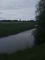
The river, nice and peaceful.
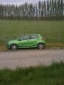
Our trusty transport.

John, taking a photo of me with the iPhone
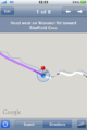
A screenshot of the maps application in the iPhone


