Difference between revisions of "2009-11-19 35 -106"
From Geohashing
imported>Redaragorn (New page: {{meetup graticule | map=<map lat="35" lon="-106" date="2009-11-19" /> | lat=35 | lon=-106 | date=2009-11-19 }} == Location == A storm water catch basin not far off Juan Tabo Blvd about ...) |
imported>Redaragorn |
||
| Line 12: | Line 12: | ||
== Participants == | == Participants == | ||
| + | * [[User:Redaragorn|Redaragorn]] and family | ||
== Plans == | == Plans == | ||
| Line 22: | Line 23: | ||
== Track == | == Track == | ||
| + | View the track on Trailguru [http://www.trailguru.com/wiki/index.php/Track:AB4T?units=imperial here]. | ||
== Pictures == | == Pictures == | ||
| Line 27: | Line 29: | ||
<gallery> | <gallery> | ||
| − | Image:2009-11-19 35 -106 - GPS.jpg| | + | Image:2009-11-19 35 -106 - GPS.jpg|The coordinates to prove I was there. |
| − | Image:2009-11-19 35 -106 - grin.jpg| | + | Image:2009-11-19 35 -106 - grin.jpg|My son and I with a pair of goofy grins. |
</gallery> | </gallery> | ||
== Achievements == | == Achievements == | ||
| + | |||
| + | [[category:Expeditions]] [[category:Coordinates reached]] | ||
Revision as of 04:19, 20 November 2009
| Thu 19 Nov 2009 in 35,-106: 35.1400064, -106.5141692 geohashing.info google osm bing/os kml crox |
Location
A storm water catch basin not far off Juan Tabo Blvd about a quarter mile south of the intersection with Spain Rd.
Participants
- Redaragorn and family
Plans
Today is looking fairly busy, but since this one is close and easily accessible, I may try to get over to the NE Heights to catch it. Anybody else feel like meeting up?
Expedition
Track
View the track on Trailguru here.
Pictures
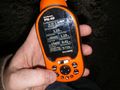
The coordinates to prove I was there.

My son and I with a pair of goofy grins.

