Difference between revisions of "2009-11-18 35 -78"
imported>Robyn (+Mt. Olive. Photos shortly.) |
imported>Jiml m (A couple of typos) |
||
| Line 12: | Line 12: | ||
==Expedition== | ==Expedition== | ||
| − | Robyn was continuing her drive from Havelock, NC to Raleigh-Duram International Airport, and turned south off highway 70 at Goldsboro with four goals: buy gas, pee, eat lunch and go to the geohash. She first went to the geohash, which was only about a twenty metre dash across a mowed field. No marker was left, as paper would be litter and natural | + | Robyn was continuing her drive from Havelock, NC to Raleigh-Duram International Airport, and turned south off highway 70 at Goldsboro with four goals: buy gas, pee, eat lunch and go to the geohash. She first went to the geohash, which was only about a twenty metre dash across a mowed field. No marker was left, as paper would be litter and natural object like sticks or stones could harm someone operating a mower. |
Then Robyn bought gas. She did not see anywhere she liked for lunch, and history does not record whether or not she peed. She did not miss her flight. A perfect record. | Then Robyn bought gas. She did not see anywhere she liked for lunch, and history does not record whether or not she peed. She did not miss her flight. A perfect record. | ||
| Line 20: | Line 20: | ||
Image:2009-11-18 35 -78.field.jpg|Nothing extraordinary about this field | Image:2009-11-18 35 -78.field.jpg|Nothing extraordinary about this field | ||
Image:2009-11-18 35 -78.gps.jpg|except that it contains the geohash coordinates | Image:2009-11-18 35 -78.gps.jpg|except that it contains the geohash coordinates | ||
| − | Image:2009-11-18 35 -78.grin.jpg| | + | Image:2009-11-18 35 -78.grin.jpg|and a grinning geohasher. |
</gallery> | </gallery> | ||
[[Category:Expeditions]] | [[Category:Expeditions]] | ||
[[Category:Coordinates reached]] | [[Category:Coordinates reached]] | ||
Revision as of 05:51, 2 January 2010
| Wed 18 Nov 2009 in 35,-78: 35.2173464, -78.0606749 geohashing.info google osm bing/os kml crox |
Contents
Location
In a field between a subdivision and a utility company in Mt. Olive, North Carolina.
Participants
- Robyn
Expedition
Robyn was continuing her drive from Havelock, NC to Raleigh-Duram International Airport, and turned south off highway 70 at Goldsboro with four goals: buy gas, pee, eat lunch and go to the geohash. She first went to the geohash, which was only about a twenty metre dash across a mowed field. No marker was left, as paper would be litter and natural object like sticks or stones could harm someone operating a mower.
Then Robyn bought gas. She did not see anywhere she liked for lunch, and history does not record whether or not she peed. She did not miss her flight. A perfect record.
Photos
- Photos
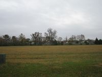
Nothing extraordinary about this field
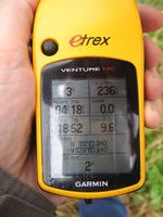
except that it contains the geohash coordinates
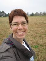
and a grinning geohasher.


