Difference between revisions of "2010-01-21 36 -76"
From Geohashing
imported>Archer27 m (changed image to gallery) |
imported>Archer27 (added achievement) |
||
| Line 29: | Line 29: | ||
File:-f4084340-4e06-4f9b-8d35-3ad19c183303-.jpeg|Arrow and park | File:-f4084340-4e06-4f9b-8d35-3ad19c183303-.jpeg|Arrow and park | ||
</gallery> | </gallery> | ||
| + | |||
| + | === Acheivements === | ||
| + | ---- | ||
| + | |||
| + | {{land geohash | user:Archer27| latitude = 36| longitude = -76| date = 2010-01-21}} | ||
[[Category:Expeditions]] | [[Category:Expeditions]] | ||
[[Category:Coordinates reached]] | [[Category:Coordinates reached]] | ||
Revision as of 19:49, 25 January 2010
| Thu 21 Jan 2010 in 36,-76: 36.7474641, -76.2267444 geohashing.info google osm bing/os kml crox |
Location
Chesapeake City Park, in the kid's playground area
Participants
Expedition
You know what sucks? Work. So I decided to take some time today to blow off the job and goahead and get my FIRST geohash. I drove down to the very convenient location in Chesapeake park. With overcast skies, some drizzling rain, and low temps there was no one there at all. I walked right into the deserted playground and found the coords. I left an arrow made of twigs on the picnic table right there. Now time to get back to what I'm supposed to be doing.
Photos
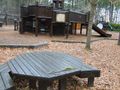
Arrow and park

Acheivements
This user earned the Land geohash achievement
|