Difference between revisions of "2010-01-23 31 -111"
From Geohashing
imported>Ilpadre m (+cat) |
imported>FippeBot m (Location) |
||
| Line 20: | Line 20: | ||
[[Category:Expeditions with photos]] | [[Category:Expeditions with photos]] | ||
[[Category:Coordinates reached]] | [[Category:Coordinates reached]] | ||
| + | {{location|US|AZ|PM}} | ||
Revision as of 00:35, 9 August 2019
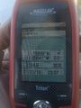
| Sat 23 Jan 2010 in Sasabe: 31.7999679, -111.0504074 geohashing.info google osm bing/os kml crox |
Expeditions
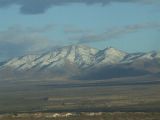
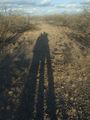
Only about a 400 meter walk from a dirt road to the geohash point. We did encounter lots of thorny bushes as well as plenty of old discarded water bottles, jackets, backpacks, and pants. Seems to be a high immigrant traffic area. Coordinates put us on a nice ridge with a great view of the recently snow covered mountains. We enjoyed a bottle of wine while taking in the views and listening to the sounds of rifle target practice.
It was then on to a steak dinner and the rest of a wonderful evening.
Sasabe, Arizona
Sasabe, Arizona
Sasabe, Arizona


