Difference between revisions of "2010-02-06 45 -122"
imported>Jiml (Update Report) |
imported>Jiml (Update Report) |
||
| Line 31: | Line 31: | ||
== Photos == | == Photos == | ||
| − | + | ||
<gallery perrow="4"> | <gallery perrow="4"> | ||
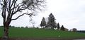
| − | Image: | + | Image:2010-02-06 45 -122-hashpoint.jpg | View of the hashpoint |
| − | |||
</gallery> | </gallery> | ||
| − | |||
| − | |||
| − | |||
Revision as of 01:41, 7 February 2010
| Sat 6 Feb 2010 in 45,-122: 45.6074741, -122.9902612 geohashing.info google osm bing/os kml crox |
Contents
Location
A field on a farm near North Plains, Oregon.
Participants
Plans
I programmed the GPS, and printed out a page from Google Maps. I never looked at them map. Maybe I shouldn't bother printing it in this sort of case.
Expedition
It turned out pretty much like I expected. I arrived, and the haspoint was clearly in a field. I went to ask at an adjacent house, which I think was the owner, but didn't find anyone there, nor in the barn, except for a fairly friendly dog.
I tried to ask at the house across the street, and there was no one there either. Since the hashpoint was a full 0.2 miles from the street, I decided it was too far to go without permission. It wasn't like standing adjacent to the ditch at the side of the road.
So, I proceeded to run my errands and head home.
Photos
View of the hashpoint
