Difference between revisions of "2010-02-15 58 -3"
imported>SuicideCraze |
imported>Jiml m (Adjust result codes) |
||
| Line 1: | Line 1: | ||
| − | |||
| − | |||
| − | |||
| − | |||
| − | |||
| − | |||
{{meetup graticule | {{meetup graticule | ||
| lat=58 | | lat=58 | ||
| Line 29: | Line 23: | ||
After stopping again a little farther up the road we had to jump across a ditch and get our feet wet on the soggy land that seems to make up the majority of this part of the world. We squelched on for maybe a hundred feet and decided that 22 feet was close enough when the next part looked particularly wet and squishy in the darkness. | After stopping again a little farther up the road we had to jump across a ditch and get our feet wet on the soggy land that seems to make up the majority of this part of the world. We squelched on for maybe a hundred feet and decided that 22 feet was close enough when the next part looked particularly wet and squishy in the darkness. | ||
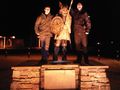
| − | We took a screenshot of the Blackberry's | + | We took a screenshot of the Blackberry's GPS and retreated to the somewhat firmer road for photos. On the way home we decided to go via John o' Groats seeing as we were practically there anyway. A worthwhile sidetrack it was too. Not only did we befriend a viking, but we also learned how far away some places were from a sign. Educational! |
== Tracklog == | == Tracklog == | ||
| Line 46: | Line 40: | ||
</gallery> | </gallery> | ||
| − | |||
| − | |||
| − | |||
| − | |||
| − | |||
| − | |||
[[Category:Expeditions]] | [[Category:Expeditions]] | ||
[[Category:Expeditions with photos]] | [[Category:Expeditions with photos]] | ||
[[Category:Coordinates reached]] | [[Category:Coordinates reached]] | ||
Revision as of 06:41, 7 March 2010
| Mon 15 Feb 2010 in 58,-3: 58.6243272, -3.1314454 geohashing.info google osm bing/os kml crox |
Location
By the side of the road, just outside Canisbay.
Participants
- SuicideCraze
- Pamela
- Spence
Plans
Heading out in the early evening, probably about 19:30, and just driving the ~15 miles to the point.
Expedition
It was all pretty uneventful, especially in comparison to the last hash. We left at about 19:30 as planned and drove to roughly where we thought the hash should be. The Blackberry had decided that it didn't want to get a GPS signal for some reason, but rebooting it fixed that. So once we got a signal we found that we needed to travel less than half a mile to reach the hash.
After stopping again a little farther up the road we had to jump across a ditch and get our feet wet on the soggy land that seems to make up the majority of this part of the world. We squelched on for maybe a hundred feet and decided that 22 feet was close enough when the next part looked particularly wet and squishy in the darkness.
We took a screenshot of the Blackberry's GPS and retreated to the somewhat firmer road for photos. On the way home we decided to go via John o' Groats seeing as we were practically there anyway. A worthwhile sidetrack it was too. Not only did we befriend a viking, but we also learned how far away some places were from a sign. Educational!
Tracklog
No tracklog this time as we didn't get a GPS signal until very near the hashpoint.
Photos
Larger versions on Picasa.
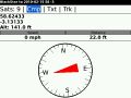
GPS at the Hash.
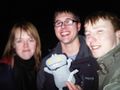
Group shot.
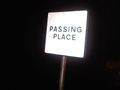
Should read "Parking Place".
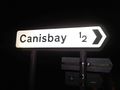
Proof we were in the area.
Our new best friend.
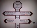
In case you've taken a very wrong turn on the way to London?


