Difference between revisions of "2010-02-22 34 -84"
From Geohashing
imported>NWoodruff (Created page with '{{meetup graticule | map=<map lat="34" lon="-84" date="2010-02-22" /> | lat=34 | lon=-84 | date=2010-02-22 | graticule_name=Roswell | graticule_link=Roswell, Georgia }} == Grati…') |
imported>NWoodruff (→Gallery) |
||
| Line 26: | Line 26: | ||
== Gallery == | == Gallery == | ||
<gallery caption="Photo Gallery" widths="200px" heights="200px" perrow="3"> | <gallery caption="Photo Gallery" widths="200px" heights="200px" perrow="3"> | ||
| − | Image:20100222_34_-84NW01.JPG| | + | Image:20100222_34_-84NW01.JPG| Hmmm... This stream isn't on Google Maps. Also I have to cross it and this is the only way to get across. |
| + | Image:20100222_34_-84NW02.JPG| 219 feet to go. I have to cross the stream. | ||
| + | Image:20100222_34_-84NW03.JPG| Proof that I walked across it. | ||
| + | Image:20100222_34_-84NW04.JPG| 1.25 feet to go. Close enough. | ||
| + | Image:20100222_34_-84NW05.JPG| Time of the meetup. | ||
| + | Image:20100222_34_-84NW06.JPG| Date of the meetup. | ||
| + | Image:20100222_34_-84NW07.JPG| Looking south up the hill. | ||
| + | Image:20100222_34_-84NW08.JPG| Looking North back across the stream, standing on the Geohash spot. | ||
| + | Image:20100222_34_-84NW09.JPG| Me standing on the Geohash spot in dire need of a haircut. | ||
</gallery> | </gallery> | ||
Revision as of 13:17, 24 February 2010
| Mon 22 Feb 2010 in Roswell: 34.0462709, -84.4020917 geohashing.info google osm bing/os kml crox |
Graticule
About
In the woods of a house in Woodstock Georgia
People
Expeditions
Gallery
- Photo Gallery
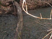
Hmmm... This stream isn't on Google Maps. Also I have to cross it and this is the only way to get across.

219 feet to go. I have to cross the stream.
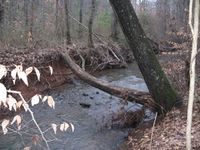
Proof that I walked across it.
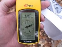
1.25 feet to go. Close enough.
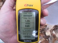
Time of the meetup.

Date of the meetup.
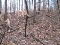
Looking south up the hill.

Looking North back across the stream, standing on the Geohash spot.

Me standing on the Geohash spot in dire need of a haircut.


Achievements
NWoodruff earned the Land geohash achievement
|