Difference between revisions of "2010-04-17 50 10"
imported>Reinhard (→Photos) |
imported>Reinhard (report) |
||
| Line 14: | Line 14: | ||
__NOTOC__ | __NOTOC__ | ||
== Location == | == Location == | ||
| − | + | On a meadow near Lindenau in the rural district of Hilburghausen in Thuringia, close to the border to Bavaria. | |
== Participants == | == Participants == | ||
| Line 20: | Line 20: | ||
== Plans == | == Plans == | ||
| − | + | For several weeks Reinhard had planned to use this Saturday for a test ride of the 3rd stage of the 2010 [http://deutschland-rundfahrt.quaeldich.de/ quaeldich.de-Deutschland-Rundfahrt] (Germany round trip by bike) from Jena to Coburg (about 155 km with 2600 m ascent). Reinhard found another rider to accompany him to Coburg. As Manu was visiting her parents, Reinhard had planned to continue the ride to her, which was about 40 km. When the Saturday hashpoint was announced, Reinhard saw that it would only mean a detour of 20 km from Coburg to Manu, so his plan was sealed. | |
== Expedition == | == Expedition == | ||
| − | + | Reinhard's companion arrived in Jena at 8:20 by train, so that was the time, when they started their test ride. As those crazy cyclists love mountains and steep roads, the trip to Coburg was quite exhausting, especially in April, when cyclists have not yet gained their best physical strength after the winter. Anyway, Reinhard knew what he would have to expect, since he was responsible for planning this stage of the nine-day round trip, which will take place from July 3rd to 11th. | |
| + | |||
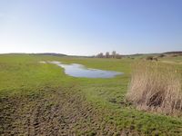
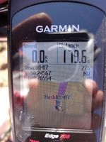
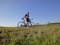
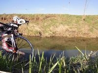
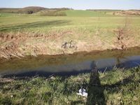
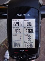
| + | After saying good-bye to the other rider, Reinhard went on directly to the hashpoint (having a short rest and a biological battery recharge at a bakery with chocolate croissant and energy bar on his way). As he knew, the hashpoint was just about 300 m from the road, but there was a small river in-between. He also knew, that there was a bridge for a field path 700 m away, so he got there and crossed the river, but was not amused seeing some water puddles covering parts of the meadow, that he'd have to cross. He managed to get around them with walking mostly on dry ground (everything else was dry after that sunny day). Shortly before he'd had to step on a rectangle of plowed field, he reached the coordinates and took the usual pictures. Reinhard didn't want to walk his bike 700 m back to the bridge, so he looked for a good spot to cross the river (or brook?). Turned out that there wasn't any comfortable spot, as it had a quite steep embankment on each side. Reinhard wanted to wade through the river nonetheless, so there was no alternative. He got out of his shoes and socks and carefully walked through the knee-deep water, carrying his bike and placing it at the opposite bank. Then he got back (his feet feeling quite cold) and fetched his camera which was taking a self-timer photo and his shoes and socks. He then barefootly went on the 100 m to the road, where he hid his dirty feet (no way to get out of the water with clean feet) in the socks. The cold water and being out of the shoes for some minutes had an astonishing refreshing effect, which made the last 40 km a piece of cake. When he arrived at Manu he had cycled 225 km with 3360 m ascent, which are good numbers for an April trip. | ||
== Tracklog == | == Tracklog == | ||
Revision as of 13:43, 18 April 2010
| Sat 17 Apr 2010 in 50,10: 50.2456688, 10.7655404 geohashing.info google osm bing/os kml crox |
Location
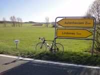
On a meadow near Lindenau in the rural district of Hilburghausen in Thuringia, close to the border to Bavaria.
Participants
Plans
For several weeks Reinhard had planned to use this Saturday for a test ride of the 3rd stage of the 2010 quaeldich.de-Deutschland-Rundfahrt (Germany round trip by bike) from Jena to Coburg (about 155 km with 2600 m ascent). Reinhard found another rider to accompany him to Coburg. As Manu was visiting her parents, Reinhard had planned to continue the ride to her, which was about 40 km. When the Saturday hashpoint was announced, Reinhard saw that it would only mean a detour of 20 km from Coburg to Manu, so his plan was sealed.
Expedition
Reinhard's companion arrived in Jena at 8:20 by train, so that was the time, when they started their test ride. As those crazy cyclists love mountains and steep roads, the trip to Coburg was quite exhausting, especially in April, when cyclists have not yet gained their best physical strength after the winter. Anyway, Reinhard knew what he would have to expect, since he was responsible for planning this stage of the nine-day round trip, which will take place from July 3rd to 11th.
After saying good-bye to the other rider, Reinhard went on directly to the hashpoint (having a short rest and a biological battery recharge at a bakery with chocolate croissant and energy bar on his way). As he knew, the hashpoint was just about 300 m from the road, but there was a small river in-between. He also knew, that there was a bridge for a field path 700 m away, so he got there and crossed the river, but was not amused seeing some water puddles covering parts of the meadow, that he'd have to cross. He managed to get around them with walking mostly on dry ground (everything else was dry after that sunny day). Shortly before he'd had to step on a rectangle of plowed field, he reached the coordinates and took the usual pictures. Reinhard didn't want to walk his bike 700 m back to the bridge, so he looked for a good spot to cross the river (or brook?). Turned out that there wasn't any comfortable spot, as it had a quite steep embankment on each side. Reinhard wanted to wade through the river nonetheless, so there was no alternative. He got out of his shoes and socks and carefully walked through the knee-deep water, carrying his bike and placing it at the opposite bank. Then he got back (his feet feeling quite cold) and fetched his camera which was taking a self-timer photo and his shoes and socks. He then barefootly went on the 100 m to the road, where he hid his dirty feet (no way to get out of the water with clean feet) in the socks. The cold water and being out of the shoes for some minutes had an astonishing refreshing effect, which made the last 40 km a piece of cake. When he arrived at Manu he had cycled 225 km with 3360 m ascent, which are good numbers for an April trip.
Tracklog
Photos
|
