Difference between revisions of "2010-04-22 36 -76"
From Geohashing
imported>Archer27 m (→Expedition) |
imported>FippeBot m (Location) |
||
| Line 34: | Line 34: | ||
[[Category:Expeditions with photos]] | [[Category:Expeditions with photos]] | ||
[[Category:Coordinates reached]] | [[Category:Coordinates reached]] | ||
| + | {{location|US|VA|VI}} | ||
Latest revision as of 01:42, 9 August 2019
| Thu 22 Apr 2010 in 36,-76: 36.8110322, -76.1206248 geohashing.info google osm bing/os kml crox |
Location
Sidewalk in a Va Beach neighborhood
Participants
Plans
Saw a nice close-by one while at work and decided to run out to it afterwards.
Expedition
I ended up taking the whole family out, since there were errands and dinner to worry about later.
Knowing it was so close, I decided to make it a little more challenging by not looking at directions at all. I didn't know if it would be reachable or not, just programmed the GPS and headed out. It didn't take too many turns to find it. It was in a surprisingly nice spot, between two rows of houses in a not-so-nice VB neighborhood. I got out while everyone else waited in the car and took my photos and made a hashmark on the sidewalk.

Photos
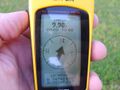
GPS
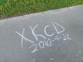
hashmark


Achievements
Archer27 earned the Land geohash achievement
|