Difference between revisions of "2010-04-28 55 13"
imported>Fasanen |
imported>Fasanen |
||
| Line 21: | Line 21: | ||
<gallery perrow="3"> | <gallery perrow="3"> | ||
| − | Image:20100428551301.JPG| | + | Image:20100428551301.JPG|Geohash flyer with navigation device |
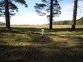
| + | Image:20100428551302.JPG|Coordinates reached | ||
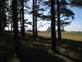
| + | Image:20100428551303.JPG|The location | ||
| + | Image:20100428551304.JPG|Me | ||
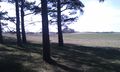
| + | Image:20100428551305.jpg|View from the location | ||
| + | Image:20100428551306.jpg|Crap quality HTC image but contains GPS data in EXIF | ||
</gallery> | </gallery> | ||
Revision as of 20:32, 28 April 2010
| Wed 28 Apr 2010 in 55,13: 55.5789415, 13.3715768 geohashing.info google osm bing/os kml crox |
Location
In the forest a few kilometers west from Häckeberga castle, Skåne, Sweden.
Participants
Plans
I learnt about geohashing a few weeks ago through a virtual cache on opencaching.se and have since then been following the hashpoint coordinates. Either I have been too busy or the coordinates have been located in the sea or in fields with growing crops but today I had some time to spare and the location seemed nice.
Expedition
Weather was fantastic. I drove the car to the hashpoint which was very easily accessed as it was located just 10-15 meters from the road in a friendly open forest close to a grassy field. After documenting the place I went to a find a geocache which was located only half a kilometer down the road.
Photos
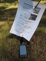
Geohash flyer with navigation device

Coordinates reached
The location

Me
View from the location
Crap quality HTC image but contains GPS data in EXIF


