Difference between revisions of "2010-05-19 54 -111"
From Geohashing
imported>B cereus (Added photos) |
imported>B cereus (corrected file names on photos) |
||
| Line 32: | Line 32: | ||
Image:Iphone 065.PNG | iPhone printscreen (press home & power at same time) | Image:Iphone 065.PNG | iPhone printscreen (press home & power at same time) | ||
Image:Iphone 066.JPG | ''C. tetani'' ridden fence | Image:Iphone 066.JPG | ''C. tetani'' ridden fence | ||
| − | Image: | + | Image:2010-05-19_54_-111_03.JPG | Cliché Canadian wildlife photo. Canadian geese and a beaver lodge. |
| − | Image: | + | Image:2010-05-19_54_-111_04.JPG | An old abandoned barn just down the road from the hash point. |
| − | Image: | + | Image:2010-05-19_54_-111_05.JPG | OH MY! |
</gallery> | </gallery> | ||
Revision as of 22:09, 10 July 2010
| Wed 19 May 2010 in 54,-111: 54.3715929, -111.5080525 geohashing.info google osm bing/os kml crox |
Location
In a field just off 2° highway 867
Participants
B cereus
Plans
On my way back to Edmonton from work, I'll try to hit as many hash points as possible.
Expedition
After a full night shift at work, I hit the road at 07:00 and by 7:30, the stock marked had opened, and I saw that I should be able to get to 4 hashes in a row. Sadly, the field is on private property only 300m away from the fence line, and I didn't feel like trespassing a barbed wire fence in. At least I got to see a black bear. So that's 0/4 so far. Next stop, 53 -111.
Photos
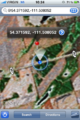
iPhone printscreen (press home & power at same time)
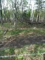
C. tetani ridden fence
- 2010-05-19 54 -111 03.JPG
Cliché Canadian wildlife photo. Canadian geese and a beaver lodge.
- 2010-05-19 54 -111 04.JPG
An old abandoned barn just down the road from the hash point.
- 2010-05-19 54 -111 05.JPG
OH MY!

