Difference between revisions of "2010-07-17 52 -1"
From Geohashing
imported>Omniscient (Created page with '== Location == In a house, Mancetter, Atherstone - decided a less intrusive waypoint was the grassy verge outside. {{meetup graticule | lat=52 | lon=-1 | date=2010-07-17 | grat…') |
imported>Omniscient (→Photos) |
||
| Line 30: | Line 30: | ||
<gallery perrow="4"> | <gallery perrow="4"> | ||
| − | + | Image:The_park.jpg|A peaceful park opposite the geohash. | |
| − | + | Image:Gippo_and_Omniscient_admiring_the_park.jpg|Gippo and Omniscient admiring the park. | |
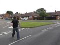
| − | Image: | + | Image:The_%27chosen%27_landmark.jpg|Without access to the geohash co-ordinates we decided the lampost outside was as good a landmark as any. |
| + | Image:Omniscient_and_the_grassy_verge.jpg|The sought after grassy verge right outside the geohash. | ||
</gallery> | </gallery> | ||
Revision as of 10:00, 24 July 2010
Contents
Location
In a house, Mancetter, Atherstone - decided a less intrusive waypoint was the grassy verge outside.
| Sat 17 Jul 2010 in Birmingham: 52.5687441, -1.5352076 geohashing.info google osm bing/os kml crox |
Participants
Expedition
Omniscient's first geohash in a long while was searching for a house in Atherstone, while in the town the surrounding area was peaceful, bordering a small park. The journey out, on the B585, was via Market Bosworth; an enjoyable and scenic trip compared with the daily mundane of City Centre commutes.
Photos
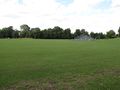
A peaceful park opposite the geohash.

Gippo and Omniscient admiring the park.

Without access to the geohash co-ordinates we decided the lampost outside was as good a landmark as any.
The sought after grassy verge right outside the geohash.


