Difference between revisions of "2010-08-08 -36 174"
From Geohashing
imported>Greenslime (→Plans) |
imported>Greenslime m |
||
| Line 47: | Line 47: | ||
Delete the next line ONLY if you have chosen the appropriate categories below. If you are unsure, don't worry. People will read your report and help you with the classification. --> | Delete the next line ONLY if you have chosen the appropriate categories below. If you are unsure, don't worry. People will read your report and help you with the classification. --> | ||
[[Category:New report]] | [[Category:New report]] | ||
| − | + | [[Category:Expedition planning]] | |
<!-- Potential categories. Please include all the ones appropriate to your expedition --> | <!-- Potential categories. Please include all the ones appropriate to your expedition --> | ||
<!-- If this is a planning page: | <!-- If this is a planning page: | ||
| − | + | ||
--> | --> | ||
Revision as of 03:36, 7 August 2010
| Sun 8 Aug 2010 in -36,174: -36.8514438, 174.8988717 geohashing.info google osm bing/os kml crox |
Location
Off the western coastline of Musick Point/Te Waiarohia or Howick golf course
Participants
Plans
Satellite imagery suggests that this hash could be accessible at low tide, hence i will ensure that i am on location at 11:00 on sunday to take a look. Research [[1]] shows that the peninsula 'encompasses a narrow band of steep coastal cliffs dominated by mature pohutukawa' hence there may be a quantity of walking up the length of the peninsula involved, probably in mud.
Expedition
Tracklog
Photos
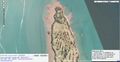
Satellite image of the hash location

Achievements