Difference between revisions of "2010-08-11 66 25"
imported>Isopekka |
imported>Isopekka |
||
| Line 1: | Line 1: | ||
| + | <!-- If you did not specify these parameters in the template, please substitute appropriate things for IMAGE, LAT, LON, and DATE (YYYY-MM-DD format) | ||
| + | |||
| + | [[Image:{{{image|IMAGE}}}|thumb|left]] | ||
| + | |||
| + | Remove this section if you don't want a image at the top (left) of your report. You should remove the "Image:" or "File:" | ||
| + | tag from your image file name, and replace the all upper-case word IMAGE in the above line. | ||
| + | |||
| + | And DON'T FORGET to add your expedition and the best photo you took to the gallery on the Main Page! We'd love to read your report, but that means we first have to discover it! | ||
| + | --> | ||
| + | |||
| + | |||
<!-- If you did not specify these parameters in the template, please substitute appropriate things for IMAGE, LAT, LON, and DATE (YYYY-MM-DD format) | <!-- If you did not specify these parameters in the template, please substitute appropriate things for IMAGE, LAT, LON, and DATE (YYYY-MM-DD format) | ||
| Line 13: | Line 24: | ||
| date=2010-08-11 | | date=2010-08-11 | ||
}} | }} | ||
| + | |||
| + | <!-- edit as necessary --> | ||
| + | __NOTOC__ | ||
| + | == Location == | ||
| + | <!-- where you've surveyed the hash to be --> | ||
| + | |||
| + | == Participants == | ||
| + | <!-- who attended --> | ||
| + | |||
| + | == Plans == | ||
| + | <!-- what were the original plans --> | ||
| + | |||
| + | == Expedition == | ||
| + | <!-- how it all turned out. your narrative goes here. --> | ||
| + | |||
| + | == Tracklog == | ||
| + | <!-- if your GPS device keeps a log, you may post a link here --> | ||
| + | |||
| + | == Photos == | ||
| + | <!-- Insert pictures between the gallery tags using the following format: | ||
| + | Image:2010-##-## ## ## Alpha.jpg | Witty Comment | ||
| + | --> | ||
| + | <gallery perrow="5"> | ||
| + | </gallery> | ||
| + | |||
| + | == Achievements == | ||
| + | {{#vardefine:ribbonwidth|800px}} | ||
| + | <!-- Add any achievement ribbons you earned below, or remove this section --> | ||
| + | |||
| + | |||
| + | <!-- =============== USEFUL CATEGORIES FOLLOW ================ | ||
| + | Delete the next line ONLY if you have chosen the appropriate categories below. If you are unsure, don't worry. People will read your report and help you with the classification. --> | ||
| + | [[Category:New report]] | ||
| + | |||
| + | <!-- Potential categories. Please include all the ones appropriate to your expedition --> | ||
| + | <!-- If this is a planning page: | ||
| + | [[Category:Expedition planning]] | ||
| + | --> | ||
| + | |||
| + | <!-- An actual expedition: | ||
| + | [[Category:Expeditions]] | ||
| + | -- and one or more of -- | ||
| + | [[Category:Expeditions with photos]] | ||
| + | [[Category:Expeditions with videos]] | ||
| + | [[Category:Expedition without GPS]] | ||
| + | --> | ||
| + | |||
| + | <!-- if you reached your coords: | ||
| + | [[Category:Coordinates reached]] | ||
| + | --> | ||
| + | |||
| + | <!-- or if you failed :( | ||
| + | [[Category:Coordinates not reached]] | ||
| + | -- and a reason -- | ||
| + | [[Category:Not reached - Mother Nature]] | ||
| + | [[Category:Not reached - No public access]] | ||
| + | [[Category:Not reached - Technology]] | ||
| + | [[Category:Not reached - Did not attempt]] | ||
| + | --> | ||
| + | |||
| + | |||
__NOTOC__ | __NOTOC__ | ||
Revision as of 17:44, 16 August 2010
| Wed 11 Aug 2010 in 66,25: 66.3196175, 25.3508862 geohashing.info google osm bing/os kml crox |
Location
Participants
Plans
Expedition
Tracklog
Photos
Achievements
Location
About 25 km south from the city of Rovaniemi, Finland.
Nollapiste sijaitsee n. 25 km Rovaniemeltä nelostietä etelään, Muurolan eteläpuolella Putaanperän kylässä Kota-aavantien päässä. Nollapisteelle on tieltä matkaa noin 400 m.
Retken suunnittelu
Tämä näytti niin helpolta, autolla suoraan perille. Töiden jälkeen ehti mainiosti hashpisteelle, ja sillä aikaa vaimolla oli mainio mahdollisuus ulkoiluttaa koiraa Hirvaan maisemissa. Kaksi kärpästä siis yhdellä iskulla.
Osallistujat
- isopekka ihan yksin
Tutkimusretki
Jännittävä hetki: elämäni ensimmäinen geohäsläysmatka! Lähdin 11.8.2010 puoli kuuden aikaan iltapäivällä autoileman kohti nollapistettä. Piha-alueita viistäen autolla pääsi noin 100 m:n päähän kohteesta. Jalkapatikassa matka jatkui entisten minkki/kettuhäkkien ohi komealle pellolle. Nollapiste oli aivan pellon eteläreunassa sammaleisen ojan vieressä.Todella kaunista maisemaa. Muutama metri etelämpänä olikin sitten jo lähes läpipääsemätön pusikko. Saappaat olivat tarpeen. Varsin helppo retki, ilmatkin olivat suosiolliset.
- Autolla yhteensä 30 km
- Kävelyä yhteensä n. 300 m
- Retken kesto 1.5 h
- Fyysinen rasittavuus (1-5): 1
(Hups, gepsistä otetussa valokuvassa ei näykään paikan koordinaatit, vaikka niin oli tarkoitus. Aloittelijan sähellystä. Kellosta kuitenkin näkee, että kyseessä oli 11. päivä, ja maisemakuvien autenttisuuden voi tarvittaessa käydä paikan päällä toteamassa.)
Valokuvia
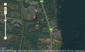
Satellite picture of the hashpoint
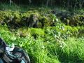
Around the zero point, pic1
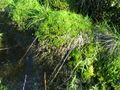
Around the zero point, pic2
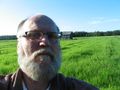
Hasher in ground zero
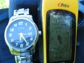
Time and place
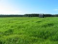
View to the North from the zero point


Saavutukset
isopekka earned the Land geohash achievement
|
Translation to English
Google Translate link for this page: