Difference between revisions of "2010-08-14 34 -84"
From Geohashing
imported>NWoodruff (Created page with '{{meetup graticule | map=<map lat="34" lon="-84" date="2010-08-14" /> | lat=34 | lon=-84 | date=2010-08-14 | graticule_name=Roswell | graticule_link=Roswell, Georgia }} == Grati…') |
imported>NWoodruff (→Gallery) |
||
| Line 23: | Line 23: | ||
== Gallery == | == Gallery == | ||
<gallery caption="Photo Gallery" widths="200px" heights="200px" perrow="3"> | <gallery caption="Photo Gallery" widths="200px" heights="200px" perrow="3"> | ||
| − | Image:20100814_34_-84NW01.JPG | | + | Image:20100814_34_-84NW01.JPG | 27.2 feet to go. Well within the 10m requirement. |
| + | Image:20100814_34_-84NW02.JPG | 2.41 feet to go. Almost the exact spot. | ||
| + | Image:20100814_34_-84NW03.JPG | Time of the meetup. | ||
| + | Image:20100814_34_-84NW04.JPG | Date of the meetup. | ||
| + | Image:20100814_34_-84NW05.JPG | Me with a Stupid Grin™ | ||
| + | Image:20100814_34_-84NW06.JPG | The distance my truck is from the actual Geohash spot. | ||
| + | Image:20100814_34_-84NW07.JPG | Looking back up the hill standing on the Geohash spot. | ||
</gallery> | </gallery> | ||
Revision as of 12:18, 15 August 2010
| Sat 14 Aug 2010 in Roswell: 34.1118306, -84.6247366 geohashing.info google osm bing/os kml crox |
Contents
Graticule
About
At the end of a subdivision west of Woodstock Georgia
People
Expeditions
Gallery
- Photo Gallery
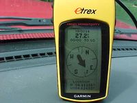
27.2 feet to go. Well within the 10m requirement.
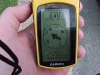
2.41 feet to go. Almost the exact spot.
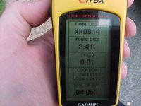
Time of the meetup.
Date of the meetup.

Me with a Stupid Grin™
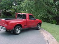
The distance my truck is from the actual Geohash spot.
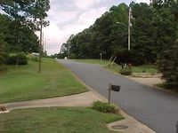
Looking back up the hill standing on the Geohash spot.


