Difference between revisions of "2010-08-15 66 26"
imported>Isopekka |
imported>Benjw (+Finnish cat) |
||
| Line 1: | Line 1: | ||
| − | |||
| − | |||
| − | |||
| − | |||
| − | |||
| − | |||
| − | |||
| − | |||
| − | |||
| − | |||
[[Image:Geohäsläys3 005.JPG|thumb|left]] | [[Image:Geohäsläys3 005.JPG|thumb|left]] | ||
| − | |||
{{meetup graticule | {{meetup graticule | ||
| lat=66 | | lat=66 | ||
| Line 16: | Line 5: | ||
| date=2010-08-15 | | date=2010-08-15 | ||
}} | }} | ||
| − | |||
| − | |||
| − | |||
== Location == | == Location == | ||
| Line 25: | Line 11: | ||
== Retken suunnittelu== | == Retken suunnittelu== | ||
| − | |||
Tänne päätin lähteä pelkästä mielijohteesta. | Tänne päätin lähteä pelkästä mielijohteesta. | ||
| Line 40: | Line 25: | ||
* Retken kesto 3h 15 min | * Retken kesto 3h 15 min | ||
* Fyysinen rasittavuus (1-5): 4 | * Fyysinen rasittavuus (1-5): 4 | ||
| + | |||
==Valokuvia == | ==Valokuvia == | ||
| − | |||
<Gallery> | <Gallery> | ||
Image:Satellite3.jpg | Satellite picture of the hashpoint | Image:Satellite3.jpg | Satellite picture of the hashpoint | ||
| Line 56: | Line 41: | ||
Image:Geohäsläys3 013.JPG| Point marked | Image:Geohäsläys3 013.JPG| Point marked | ||
Image:Geohäsläys3 009.JPG| The hashpoint was middle of nothing, but the expedition was great! | Image:Geohäsläys3 009.JPG| The hashpoint was middle of nothing, but the expedition was great! | ||
| − | |||
</Gallery> | </Gallery> | ||
| Line 62: | Line 46: | ||
== Saavutukset == | == Saavutukset == | ||
{{#vardefine:ribbonwidth|800px}} | {{#vardefine:ribbonwidth|800px}} | ||
| − | |||
| − | |||
| − | |||
{{Virgin graticule | {{Virgin graticule | ||
| − | |||
| latitude = 66 | | latitude = 66 | ||
| longitude = 26 | | longitude = 26 | ||
| date = 2010-08-15 | | date = 2010-08-15 | ||
| name = isopekka | | name = isopekka | ||
| − | |||
}} | }} | ||
| Line 79: | Line 58: | ||
[http://translate.google.com/translate?hl=en&sl=auto&tl=en&u=http%3A%2F%2Fwiki.xkcd.com%2Fgeohashing%2F2010-08-11_66_25] | [http://translate.google.com/translate?hl=en&sl=auto&tl=en&u=http%3A%2F%2Fwiki.xkcd.com%2Fgeohashing%2F2010-08-11_66_25] | ||
| − | |||
| − | |||
| − | |||
[[Category:Expeditions]] | [[Category:Expeditions]] | ||
| − | |||
[[Category:Expeditions with photos]] | [[Category:Expeditions with photos]] | ||
[[Category:Coordinates reached]] | [[Category:Coordinates reached]] | ||
| + | [[Category:Pages in Finnish]] | ||
Revision as of 07:58, 12 October 2010

| Sun 15 Aug 2010 in 66,26: 66.4885295, 26.2567461 geohashing.info google osm bing/os kml crox |
Contents
Location
About 35 km from the city of Rovaniemi, Finland. About 10 km northeast from the village Oikarainen.
Retken suunnittelu
Tänne päätin lähteä pelkästä mielijohteesta.
Osallistujat
Tutkimusretki
Matka alkoi klo 17.40. Ensin ajelin Oikaraisen kylään, sieltä Permantokosken voimalaitokselle ja edelleen noin 10 km hiekkatietä. Lopuksi rytyyttelin autolla viimeiset 1.6 km kuoppaista pikkutietä pitkin, pidemmälle ei pääsytkään autolla. Jäljelle jäi noin 2 km kävelyä pääasiassa suolla. Viimeiset 50 metriä pääsin kulkemaan kuivalla maalla, mutta kulkua hidastivat nyt kaadetut pienet männyt. Pääsin kuitenkin perille. Hikeä valui ja juomaa kului. Takaisin tulin täsmälleen samaa reittiä. Kotona olin noin klo 21.00. Oikein mukava pieni iltalenkki!
- Autolla yhteensä 68 km
- Kävelyä yhteensä n. 4 km
- Retken kesto 3h 15 min
- Fyysinen rasittavuus (1-5): 4
Valokuvia
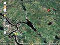
Satellite picture of the hashpoint
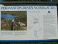
Power Station of Permantokoski about 10 km from the hashpoint
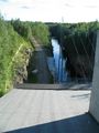
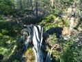
View from the Power Station
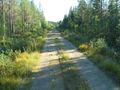
Address: Kuluksentie 681.Still 1.6 km by car
And now 2 km walking...
The bed of a moose (or a reindeer)
Still 1 km walking...
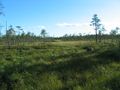
...and finally at hashpoint!
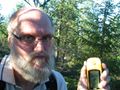
Happy Hasher
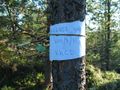
At the Point
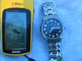
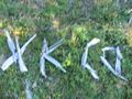
Point marked
The hashpoint was middle of nothing, but the expedition was great!


Saavutukset
Translation to English
Google Translate link for this page: