Difference between revisions of "2010-08-21 42 -71"
imported>Wwwi7891 |
imported>Wwwi7891 |
||
| Line 24: | Line 24: | ||
<gallery perrow="4"> | <gallery perrow="4"> | ||
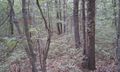
| − | Image:2010-08-21_42_-71_Trail.jpg | + | Image:2010-08-21_42_-71_Trail.jpg|Some shots of the trail. |
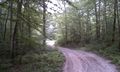
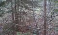
Image:2010-08-21_42_-71_Trail_2.jpg | Image:2010-08-21_42_-71_Trail_2.jpg | ||
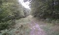
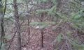
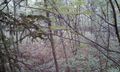
Image:2010-08-21_42_-71_Trail_3.jpg | Image:2010-08-21_42_-71_Trail_3.jpg | ||
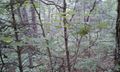
| − | Image:2010-08-21_42_-71_Scenery.jpg | + | Image:2010-08-21_42_-71_Scenery.jpg|There were a lot of scenic views while hiking along here, too bad the weather didn't hold up. |
| − | Image:2010-08-21_42_-71_Underbrush.jpg | + | Image:2010-08-21_42_-71_Underbrush.jpg|Some of the underbrush I had to wade through. |
| − | Image:2010-08-21_42_-71_Hashpoint.jpg | + | Image:2010-08-21_42_-71_Hashpoint.jpg|Finally reached the hashpoint. |
Image:2010-08-21_42_-71_Hashpoint_2.jpg | Image:2010-08-21_42_-71_Hashpoint_2.jpg | ||
Image:2010-08-21_42_-71_Hashpoint_3.jpg | Image:2010-08-21_42_-71_Hashpoint_3.jpg | ||
Image:2010-08-21_42_-71_Hashpoint_4.jpg | Image:2010-08-21_42_-71_Hashpoint_4.jpg | ||
| − | Image:2010-08-21_42_-71_Marker.jpg | + | Image:2010-08-21_42_-71_Marker.jpg|I wonder how long before a wild animal runs off with my marker. |
| − | Image:2010-08-21_42_-71_Proof.png | + | Image:2010-08-21_42_-71_Proof.png|I took some screenshots of my phone as proof...forgot to get the date in there though. |
Image:2010-08-21_42_-71_Proof_2.png | Image:2010-08-21_42_-71_Proof_2.png | ||
</gallery> | </gallery> | ||
Revision as of 05:30, 22 August 2010
| Sat 21 Aug 2010 in 42,-71: 42.0014348, -71.7931139 geohashing.info google osm bing/os kml crox |
Location
The Buck Hill Management Area in Pascoag, RI. Relatively secluded public woods with several hiking trails. The point is in some very dense woods about 200 feet off one of the main paths.
Participants
Expedition
This was my first geohash, and it turned out to be a pretty good one. After packing the essentials I hopped in the Sciencemobile (my dad's Prius) and drove about 60 miles from Boston to Pascoag. The place was kind of hard to find, it ended up being an unmarked dirt path off of a 3 mile long back country road. The trek to the hash was fairly long and uneventful, the only person I ran into was a guy out for a drive with his dog in the parking lot. After reaching the end of the trail I trekked through the underbrush for about 20 minutes I managed to find the hashpoint. After dropping a marker and taking some pictures I went back to the Sciencemobile and headed over to a local Wendy's for a delicious Baconator (hells yeah). All in all it was a good day.
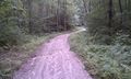
Some shots of the trail.
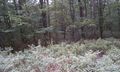
There were a lot of scenic views while hiking along here, too bad the weather didn't hold up.
Some of the underbrush I had to wade through.
Finally reached the hashpoint.
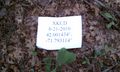
I wonder how long before a wild animal runs off with my marker.

I took some screenshots of my phone as proof...forgot to get the date in there though.