Difference between revisions of "2010-10-09 60 24"
imported>PekkaR |
imported>Benjw (remove unused bits of expedition template) |
||
| Line 1: | Line 1: | ||
| − | |||
| − | |||
| − | |||
| − | |||
| − | |||
| − | |||
| − | |||
| − | |||
| − | |||
| − | |||
| − | |||
{{meetup graticule | {{meetup graticule | ||
| lat=60 | | lat=60 | ||
| Line 16: | Line 5: | ||
}} | }} | ||
| − | |||
__NOTOC__ | __NOTOC__ | ||
== Location == | == Location == | ||
| − | |||
On the hill near a block of flats in Paavola in Hyvinkää [http://kansalaisen.karttapaikka.fi/linkki?scale=4000&text=hash+20101009&srs=EPSG%3A3067&y=6724945&mode=rasta&x=381658&lang=fi[Karttapaikka map]]. | On the hill near a block of flats in Paavola in Hyvinkää [http://kansalaisen.karttapaikka.fi/linkki?scale=4000&text=hash+20101009&srs=EPSG%3A3067&y=6724945&mode=rasta&x=381658&lang=fi[Karttapaikka map]]. | ||
---- | ---- | ||
| + | |||
Hässipiste sijaitsee Hyvinkäällä Paavolan kaupunginosassa kukkulan rinteessä lähellä tornitaloa [http://kansalaisen.karttapaikka.fi/linkki?scale=4000&text=hash+20101009&srs=EPSG%3A3067&y=6724945&mode=rasta&x=381658&lang=fi[Karttapaikka]]. | Hässipiste sijaitsee Hyvinkäällä Paavolan kaupunginosassa kukkulan rinteessä lähellä tornitaloa [http://kansalaisen.karttapaikka.fi/linkki?scale=4000&text=hash+20101009&srs=EPSG%3A3067&y=6724945&mode=rasta&x=381658&lang=fi[Karttapaikka]]. | ||
== Participants == | == Participants == | ||
| − | |||
* [[User:PekkaR|PekkaR]] | * [[User:PekkaR|PekkaR]] | ||
== Plans == | == Plans == | ||
| − | |||
I'm now greatly interesting in geohashing. I've reached two hashpoints in Hämeenlinna. Today's point was in Hyvinkää, only a half hour drive away. So I decided to continue my Consecutive geohash. | I'm now greatly interesting in geohashing. I've reached two hashpoints in Hämeenlinna. Today's point was in Hyvinkää, only a half hour drive away. So I decided to continue my Consecutive geohash. | ||
| Line 38: | Line 24: | ||
== Expedition == | == Expedition == | ||
| − | |||
I found parking place by Notkokatu and there was a little walk to the hill where hashpoint were. It was about 3:45 pm when I reached the place. On the hill was urban forest and near was a seven floor block of flats. However I didn't notice anybody staring from window or balcony. I walked around the hashpoint but couldn't get photo of zero point coordinates. | I found parking place by Notkokatu and there was a little walk to the hill where hashpoint were. It was about 3:45 pm when I reached the place. On the hill was urban forest and near was a seven floor block of flats. However I didn't notice anybody staring from window or balcony. I walked around the hashpoint but couldn't get photo of zero point coordinates. | ||
| Line 46: | Line 31: | ||
== Tracklog == | == Tracklog == | ||
| − | |||
<gallery perrow="4"> | <gallery perrow="4"> | ||
Image:2010-10-09_60-24_track.gif | Tracklog | Image:2010-10-09_60-24_track.gif | Tracklog | ||
| Line 52: | Line 36: | ||
== Photos == | == Photos == | ||
| − | |||
| − | |||
| − | |||
<gallery perrow="3"> | <gallery perrow="3"> | ||
Image:2010-10-09_60-24_gps.jpg | GPSr near hashpoint | Image:2010-10-09_60-24_gps.jpg | GPSr near hashpoint | ||
| Line 65: | Line 46: | ||
== Achievements == | == Achievements == | ||
{{#vardefine:ribbonwidth|800px}} | {{#vardefine:ribbonwidth|800px}} | ||
| − | |||
{{consecutive geohash | count = 3 | latitude = 61 | longitude = 24 | date = 2010-10-07 | name = PekkaR }} | {{consecutive geohash | count = 3 | latitude = 61 | longitude = 24 | date = 2010-10-07 | name = PekkaR }} | ||
| − | |||
| − | |||
| − | |||
| − | |||
| − | |||
| − | |||
| − | |||
| − | |||
| − | |||
[[Category:Expeditions]] | [[Category:Expeditions]] | ||
| − | |||
| − | |||
[[Category:Expeditions with photos]] | [[Category:Expeditions with photos]] | ||
| − | |||
| − | |||
| − | |||
| − | |||
[[Category:Coordinates reached]] | [[Category:Coordinates reached]] | ||
| − | |||
| − | |||
| − | |||
| − | |||
| − | |||
| − | |||
| − | |||
| − | |||
| − | |||
| − | |||
Revision as of 09:30, 10 October 2010
| Sat 9 Oct 2010 in 60,24: 60.6427434, 24.8359639 geohashing.info google osm bing/os kml crox |
Location
On the hill near a block of flats in Paavola in Hyvinkää [Karttapaikka map].
Hässipiste sijaitsee Hyvinkäällä Paavolan kaupunginosassa kukkulan rinteessä lähellä tornitaloa [Karttapaikka].
Participants
Plans
I'm now greatly interesting in geohashing. I've reached two hashpoints in Hämeenlinna. Today's point was in Hyvinkää, only a half hour drive away. So I decided to continue my Consecutive geohash.
Olen nyt intoutunut geohässäilyyn. Kaksi onnistunutta retkeä on takana ja kun tämän päivän piste oli Hyvinkäällä, jonne on runsaan puolen tunnin matka, päätin jatkaa hässäilyputkea.
Expedition
I found parking place by Notkokatu and there was a little walk to the hill where hashpoint were. It was about 3:45 pm when I reached the place. On the hill was urban forest and near was a seven floor block of flats. However I didn't notice anybody staring from window or balcony. I walked around the hashpoint but couldn't get photo of zero point coordinates.
Sopiva parkkipaikka löytyi Notkokadun laidalta ja sieltä oli runsaan sadan metrin kävely kukkulalle, jossa päivän piste sijaitsi. Kello oli 15:45 kun pääsin pelipaikalle. Kukkulalla oli kaupunkimetsää, risteileviä polkuja ja laella seitsenkerroksinen tornitalo. Haahuilin nollapisteen tienoilla odottaen gepsin rauhoittumista. En huomannut että kukaan olisi tarkkaillut liikkeitäni ikkunasta tai parvekkeelta. Ihan tarkoista koordinaateista en onnistunut saamaan kuvaa, mutta gepsin jälki osoittaa että kävin pisteellä.
Tracklog
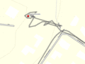
Tracklog

Photos
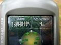
GPSr near hashpoint
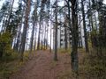
The hill 1
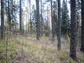
The hill 2
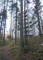
The house
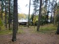
Downhill


Achievements
PekkaR earned the Consecutive geohash achievement
|