Difference between revisions of "2009-08-27 36 139"
From Geohashing
imported>Starbird m |
imported>Starbird (ancient report) |
||
| Line 1: | Line 1: | ||
| + | [[Image:{{{image|2009-08-27 36 139 raptor.jpg}}}|thumb|left]] | ||
| − | |||
| − | |||
| − | |||
| − | |||
| − | |||
| − | |||
| − | |||
| − | |||
| − | |||
{{meetup graticule | {{meetup graticule | ||
| lat=36 | | lat=36 | ||
| Line 18: | Line 10: | ||
__NOTOC__ | __NOTOC__ | ||
== Location == | == Location == | ||
| − | + | Up a hill in the woods, a few hundred meters from the Iwafune train station. | |
== Participants == | == Participants == | ||
| − | + | [[User:starbird|星鳥]] | |
| − | |||
| − | |||
| − | |||
| − | |||
== Expedition == | == Expedition == | ||
| − | + | To follow. | |
| − | == | + | == Photos == |
| − | |||
| − | |||
| − | |||
| − | |||
| − | |||
<gallery perrow="5"> | <gallery perrow="5"> | ||
| + | Image:2009-08-27 36 139 iwafune.jpg | Iwafune eki | ||
| + | Image:2009-08-27 36 139 fire.jpg | Please do not set the woods on fire, even you can't read Japanese | ||
| + | Image:2009-08-27 36 139 log.jpg | Heading in | ||
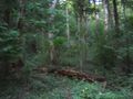
| + | Image:2009-08-27 36 139 morewoods.jpg | It's dense in here | ||
| + | Image:2009-08-27 36 139 woods.jpg | | ||
| + | Image:2009-08-27 36 139 skywoods.jpg | Occasional glimpse | ||
| + | Image:2009-08-27 36 139 nogrin.jpg | Stupid Grimace? | ||
| + | Image:2009-08-27 36 139 proof.jpg | Almost exactly...somewhere | ||
</gallery> | </gallery> | ||
| Line 43: | Line 34: | ||
{{#vardefine:ribbonwidth|800px}} | {{#vardefine:ribbonwidth|800px}} | ||
<!-- Add any achievement ribbons you earned below, or remove this section --> | <!-- Add any achievement ribbons you earned below, or remove this section --> | ||
| + | {{Velociraptor geohash | latitude = 36 | longitude = 139 | date = 2009-08-27 | name = starbird | image = 2009-08-27 36 139 raptor.jpg }} | ||
| + | {{Public transport geohash | latitude = 36 | longitude = 139 | date = 2009-08-27 | busline = the Ryōmō Line | name = starbird | image = 2009-08-27 36 139 iwafune.jpg }} | ||
| − | |||
| − | |||
| − | |||
| − | |||
| − | |||
| − | |||
| − | |||
| − | |||
| − | |||
| − | |||
| − | |||
[[Category:Expeditions]] | [[Category:Expeditions]] | ||
| − | |||
[[Category:Expeditions with photos]] | [[Category:Expeditions with photos]] | ||
| − | |||
| − | |||
| − | |||
| − | |||
| − | |||
[[Category:Coordinates reached]] | [[Category:Coordinates reached]] | ||
| − | |||
| − | |||
| − | |||
| − | |||
| − | |||
| − | |||
| − | |||
| − | |||
| − | |||
| − | |||
| − | |||
| − | |||
| − | |||
| − | |||
| − | |||
| − | |||
| − | |||
| − | |||
Revision as of 06:33, 20 July 2012

| Thu 27 Aug 2009 in 36,139: 36.3297327, 139.6587506 geohashing.info google osm bing/os kml crox |
Location
Up a hill in the woods, a few hundred meters from the Iwafune train station.
Participants
Expedition
To follow.
Photos
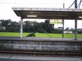
Iwafune eki
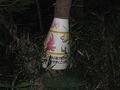
Please do not set the woods on fire, even you can't read Japanese
Heading in

It's dense in here
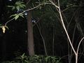
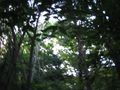
Occasional glimpse
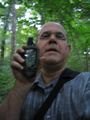
Stupid Grimace?
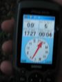
Almost exactly...somewhere


Achievements
starbird earned the Velociraptor Geohash Achievement
|
starbird earned the Public transport geohash achievement
|