Difference between revisions of "2010-10-19 -36 174"
From Geohashing
imported>Greenslime m (Created page with '{{subst:Expedition |lat = -36 |lon = 174 |date = 2010-10-19 }}') |
imported>Greenslime m |
||
| Line 1: | Line 1: | ||
| − | |||
| − | |||
| − | |||
| − | |||
| − | |||
| − | |||
| − | |||
| − | |||
| − | |||
| − | |||
{{meetup graticule | {{meetup graticule | ||
| lat=-36 | | lat=-36 | ||
| Line 15: | Line 5: | ||
}} | }} | ||
| − | + | ||
__NOTOC__ | __NOTOC__ | ||
== Location == | == Location == | ||
| − | + | On a beach (likely muddy) off the coast of the suburb of Glendowie, Auckland | |
== Participants == | == Participants == | ||
| − | + | *[[User:Greenslime|Greenslime]] | |
== Plans == | == Plans == | ||
| − | + | Low tides at 11:30, high at 17:47, I would like to get there somewhere in between to avoid wet feet. Forgot to bring my gumboots to work.... | |
== Expedition == | == Expedition == | ||
| Line 33: | Line 23: | ||
== Photos == | == Photos == | ||
| − | |||
| − | |||
| − | |||
<gallery perrow="5"> | <gallery perrow="5"> | ||
| + | File:2010-10-19 -36 174 Hash Map.JPG|Satellite imagery | ||
</gallery> | </gallery> | ||
| Line 44: | Line 32: | ||
| − | + | [[Category:Expedition planning]] | |
| − | |||
| − | [[Category: | ||
| − | |||
| − | |||
| − | |||
| − | |||
<!-- An actual expedition: | <!-- An actual expedition: | ||
Revision as of 18:29, 18 October 2010
| Tue 19 Oct 2010 in -36,174: -36.8608726, 174.8830147 geohashing.info google osm bing/os kml crox |
Location
On a beach (likely muddy) off the coast of the suburb of Glendowie, Auckland
Participants
Plans
Low tides at 11:30, high at 17:47, I would like to get there somewhere in between to avoid wet feet. Forgot to bring my gumboots to work....
Expedition
Tracklog
Photos
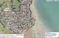
Satellite imagery

Achievements