Difference between revisions of "2010-10-30 65 24"
From Geohashing
imported>Jiml m (Fix minor typos) |
|||
| Line 1: | Line 1: | ||
| − | |||
| − | |||
| − | |||
| − | |||
| − | |||
| − | |||
| − | |||
| − | |||
| − | |||
| − | |||
[[Image:Kalix 001.JPG|thumb|left]] | [[Image:Kalix 001.JPG|thumb|left]] | ||
| Line 26: | Line 16: | ||
In the forest near the city of Tornio. | In the forest near the city of Tornio. | ||
| − | |||
| − | |||
| Line 40: | Line 28: | ||
== Expedition == | == Expedition == | ||
| − | We were on the way to | + | We were on the way to the gc-meeting, which was held in Kalix, Sweden. Very luckily this hashpoint was sufficiently close to the road, so we had to walk only 400 meters to reach the hashpoint. So we took a nice walk and found this Finnish forest point at 9:46 am. No other people or animals were seen. We left a marker and hoped that maybe some moose hunter would see it. |
| − | |||
Revision as of 14:43, 31 October 2010

| Sat 30 Oct 2010 in 65,24: 65.8277738, 24.2624876 geohashing.info google osm bing/os kml crox |
Contents
Location
In the forest near the city of Tornio.
Participants
Expedition
We were on the way to the gc-meeting, which was held in Kalix, Sweden. Very luckily this hashpoint was sufficiently close to the road, so we had to walk only 400 meters to reach the hashpoint. So we took a nice walk and found this Finnish forest point at 9:46 am. No other people or animals were seen. We left a marker and hoped that maybe some moose hunter would see it.
- Walking total 0.8 km
- By car about 120 km from home to Tornio.
- Physical efforts needed (1-5): 2
Photos taken by isopekka
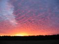
In Tervola, on the way from Rovaniemi to Tornio.
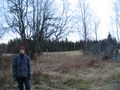
Thejoni ready to his first hashwalk.
The proof.
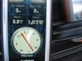
The Hashpoint.
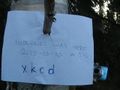
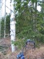
Hashpoint marked.
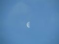
The moon as seen from the hashpoint.


Achievements of isopekka
isopekka achieved level 3 of the Minesweeper Geohash achievement
|
Achievements of thejoni
thejoni earned the Land geohash achievement
|