Difference between revisions of "2010-12-12 55 13"
imported>Fasanen (plans) |
imported>Fasanen (Expedition and photos) |
||
| Line 7: | Line 7: | ||
__NOTOC__ | __NOTOC__ | ||
== Location == | == Location == | ||
| − | In a field just north of Sjörup. | + | In a field just north west of Sjörup. |
== Participants == | == Participants == | ||
| Line 16: | Line 16: | ||
== Expedition == | == Expedition == | ||
| − | + | This was a geohash close to home and I decided to spice it up a bit by trying to make it a no-batteries-frozen-bicycle hash. I calculated the hash to be located 40 meters in bearing 290° from the first crossing on Kobrovägen (Cow bridge road), so this time the good old compass went down the backpack too. My bike is in very poor condition. I have not used it for the past ten years and it was not suitable for the current road conditions. I borrowed my wife’s. It’s also close to junk but still gets the job done. | |
| − | + | I got to the old bridge crossing the Skivarp stream when I met a lady waking her dog. She thought I was bold bicycling on the icy road. I told her not to worry; an empty head protected by a helmet, what could possibly happen? She laughed and I pressed on. There was a geohash to be reached! | |
| − | + | ||
| + | I finally got to the crossing where I parked the bike. It actually fell to the ground because of the bad kickstand. I started to rummage around my backpack in search for the compass when a young man came out from one of the nearby houses. He asked if I needed help. I said no and that I just needed to get to some coordinates 40 meters out in the field. To my happy surprise he assumed I was a ''geocacher''. He had tried that himself. I started to describe geohashing. Luckily I had brought the Active geohasher leaflet which made things a bit easier to explain. In the end I gave him the leaflet and he seemed interested. It was nice not to be treated as a lunatic alien for a change. | ||
| + | |||
| + | I paced out 40 meters, bearing 290° in the snowy field and took some pictures. It was -6° C in the air and a bit windy. I went back to the bike and started the ride back home; now slightly downhill with the wind from behind. Great! | ||
== Photos == | == Photos == | ||
| − | |||
| − | |||
| − | |||
<gallery perrow="5"> | <gallery perrow="5"> | ||
| + | Image:201012125513 planning.JPG | Planning a "No batteries" | ||
| + | Image:201012125513 sugarmill.JPG | Skivarp sugar works, 1901-1960 | ||
| + | Image:201012125513 bridge.JPG | The Skivarp bridge, 1790 | ||
| + | Image:201012125513 mound.JPG | Hålehög, bronze/iron age | ||
| + | Image:201012125513 railroad.JPG | Skivarp-Ystad railroad, 1901-1918 | ||
| + | Image:201012125513 church1.JPG | Västra Nöbbelöv church, 12th century | ||
| + | Image:201012125513 signs.JPG | Information overload with the Baltic sea in the background | ||
| + | Image:201012125513 church2.JPG | Sjörup old church, around 1160 | ||
| + | Image:201012125513 finalpush.JPG | Kobrovägen (Cow bridge road) | ||
| + | Image:201012125513 churchandsigns.JPG | Sjörup old church seen from Kobrovägen | ||
| + | Image:201012125513 lookwest.JPG | looking_west@geohash | ||
| + | Image:201012125513 looksouth.JPG |looking_south@geohash | ||
| + | Image:201012125513 interestedingh.JPG | Owner of this house might get interested in geohashing | ||
| + | Image:201012125513 meathash.JPG | me@geohash | ||
| + | Image:201012125513 subzero.JPG | Frozen hash | ||
| + | Image:201012125513 bybike.JPG | Going home | ||
| + | Image:201012125513 grin.JPG | Grin™ | ||
</gallery> | </gallery> | ||
| + | |||
== Achievements == | == Achievements == | ||
| Line 32: | Line 50: | ||
<!-- Add any achievement ribbons you earned below, or remove this section --> | <!-- Add any achievement ribbons you earned below, or remove this section --> | ||
| − | |||
| − | |||
| − | |||
| − | |||
| − | |||
| − | |||
| − | |||
| − | |||
| − | |||
| − | |||
[[Category:Expeditions]] | [[Category:Expeditions]] | ||
| − | |||
[[Category:Expeditions with photos]] | [[Category:Expeditions with photos]] | ||
| − | |||
[[Category:Expedition without GPS]] | [[Category:Expedition without GPS]] | ||
| − | |||
| − | |||
| − | |||
[[Category:Coordinates reached]] | [[Category:Coordinates reached]] | ||
| − | |||
| − | |||
| − | |||
| − | |||
| − | |||
| − | |||
| − | |||
| − | |||
| − | |||
| − | |||
Revision as of 22:42, 12 December 2010
| Sun 12 Dec 2010 in 55,13: 55.4447425, 13.6258899 geohashing.info google osm bing/os kml crox |
Location
In a field just north west of Sjörup.
Participants
Plans
It's close to Fasanen's home (3.5 kilometers) so he will get there by bike. Skis might not be necessary as the geohash seems quite close to a road. According to SMHI it might get a bit chilly. --Fasanen 16:18, 10 December 2010 (UTC)
Expedition
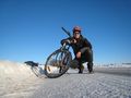
This was a geohash close to home and I decided to spice it up a bit by trying to make it a no-batteries-frozen-bicycle hash. I calculated the hash to be located 40 meters in bearing 290° from the first crossing on Kobrovägen (Cow bridge road), so this time the good old compass went down the backpack too. My bike is in very poor condition. I have not used it for the past ten years and it was not suitable for the current road conditions. I borrowed my wife’s. It’s also close to junk but still gets the job done.
I got to the old bridge crossing the Skivarp stream when I met a lady waking her dog. She thought I was bold bicycling on the icy road. I told her not to worry; an empty head protected by a helmet, what could possibly happen? She laughed and I pressed on. There was a geohash to be reached!
I finally got to the crossing where I parked the bike. It actually fell to the ground because of the bad kickstand. I started to rummage around my backpack in search for the compass when a young man came out from one of the nearby houses. He asked if I needed help. I said no and that I just needed to get to some coordinates 40 meters out in the field. To my happy surprise he assumed I was a geocacher. He had tried that himself. I started to describe geohashing. Luckily I had brought the Active geohasher leaflet which made things a bit easier to explain. In the end I gave him the leaflet and he seemed interested. It was nice not to be treated as a lunatic alien for a change.
I paced out 40 meters, bearing 290° in the snowy field and took some pictures. It was -6° C in the air and a bit windy. I went back to the bike and started the ride back home; now slightly downhill with the wind from behind. Great!
Photos
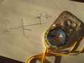
Planning a "No batteries"
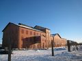
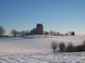
Skivarp sugar works, 1901-1960
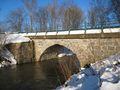
The Skivarp bridge, 1790
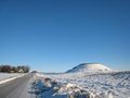
Hålehög, bronze/iron age
Skivarp-Ystad railroad, 1901-1918
Västra Nöbbelöv church, 12th century
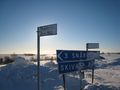
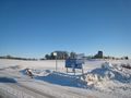
Information overload with the Baltic sea in the background
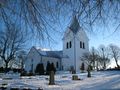
Sjörup old church, around 1160
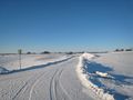
Kobrovägen (Cow bridge road)
Sjörup old church seen from Kobrovägen
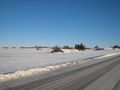
looking_west@geohash
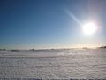
looking_south@geohash
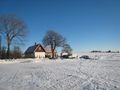
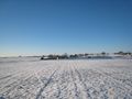
Owner of this house might get interested in geohashing
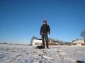
me@geohash
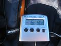
Frozen hash
Going home

Grin™


