Difference between revisions of "2010-12-19 49 -123"
imported>Jiml m (Expand template) |
imported>Thepiguy (port port) |
||
| Line 1: | Line 1: | ||
| − | |||
| − | |||
| − | |||
| − | |||
| − | |||
| − | |||
| − | |||
| − | |||
| − | |||
| − | |||
| − | |||
| − | |||
| − | |||
{{meetup graticule | {{meetup graticule | ||
| lat=49 | | lat=49 | ||
| Line 18: | Line 5: | ||
}} | }} | ||
| − | |||
__NOTOC__ | __NOTOC__ | ||
| − | |||
| − | |||
| + | [[Image:2010-12-19 49 -123 nirvana.JPG | thumb|left]] | ||
== Participants == | == Participants == | ||
| − | + | * [[User:thepiguy]] | |
| + | * Jafo | ||
| + | |||
| + | == Location == | ||
| + | Only a few kilometers from the shores of Garibaldi lake! How could we not try this! | ||
| − | + | December, you say? Snow, you say? We'll see about that! | |
| − | |||
== Expedition == | == Expedition == | ||
| − | + | Given that there was only slightly more than 8 hours of daylight, time would definitely be a factor, so the daring duo of alpine adventurers set off in the wee hours of the morning. Several hours of driving later, they exited their vehicle, donned their winter boots, hoisted their packs and set off down the trail! | |
| − | + | They first walked 2km to the snowed-in parking lot where the trail actually began. From there they began an endless (read: 6km) series of painful switchbacks that would carry them up the mountain. thepiguy quickly decided he was tired of carrying his snowshoes on his back and opted to put them on his feet. Weather this actually made walking easier, or just made his pack lighter, Jafo decided to follow suit. At this point the trees were dense and the snow compact, making for easy going. As they progressed upward the snow began to accumulate but thankfully there was a deep track worn in the trail by other recent hikers. | |
| − | |||
| − | + | At the 6km marker the trail split in two with the left branch leading off to a camp ground and the right branch leading to the lake. Sadly, there had been little recent traffic to the lake and the trail was left untouched and buried under several feet of fresh snow. <nowiki>*sigh*</nowiki> | |
| − | + | ||
| − | + | For the most part, the trail was still easy to follow, so they trudged on enjoying the untouched powder and the beautiful terrain. The path rolled up and down through the trees, over small bridges and next to a few smaller lakes. Occasionally they found themselves following animal tracks in the snow and figured that a small rabbit probably knew the trail better than they did anyway. Nearing the lake, the path made a few sharp turns and managed to free itself of the pair of persistent hikers. They were able to find the path again, but not before unknowingly crossing a large stream on a bridge made of snow, rather than the bridge made of wood and steel. | |
| − | -- | + | |
| − | + | They found their way to a wooden shelter on the edge of the lake and collapsed onto a wooden bench in order to have a rest. thepiguy hopefully turned on his GPS in order to check the remaining distance to the hashpoint. He winced and let out a small cry of pain when a rather large number appeared on the display. | |
| − | + | ||
| + | It was now almost 2:00pm, meaning only about 2 hours of daylight left, and seeing as they had started at 8:00am they would already be returning by dark. Fortunately for therpiguy, it was Jafo who was responsible for the sanity checks on this trip: Having traveled 11km thus far (and with their combined snowshoeing experience totaling a little over 22km --No, I didn't mess up the math--) it was probably for the best that they chose not to wander over 2km off of the trail into the wilderness. | ||
| + | |||
| + | With the stresses of reaching the hash point now lifted, they were left with nothing else to do but rest, eat some lunch and admire the spectacular view! | ||
| − | |||
| − | |||
| − | |||
| − | + | Oh, they had to get back to their car too. But that only took another 5 hours. | |
| − | |||
| − | |||
| − | <!-- | + | == Images == |
| − | + | <gallery> | |
| − | + | Image:2010-12-19_49_-123_driving.JPG|Crazy weather along the highway in the morning. | |
| − | --> | + | Image:2010-12-19_49_-123_timmy.JPG|The first stop in any good Canadian geohash! |
| + | Image:2010-12-19_49_-123_gear.JPG|Getting ready to start! | ||
| + | Image:2010-12-19_49_-123_start.JPG|Time to start! | ||
| + | Image:2010-12-19_49_-123_hiking.JPG|Up we go! | ||
| + | Image:2010-12-19_49_-123_fork.JPG|Straight ahead Capt'n! | ||
| + | Image:2010-12-19_49_-123_trudge.JPG|The going gets tough. | ||
| + | Image:2010-12-19_49_-123_bridge.JPG|Walking across a snow covered bridge. | ||
| + | Image:2010-12-19_49_-123_trax.JPG|Bunnies! | ||
| + | Image:2010-12-19_49_-123_barrier.JPG|Encountering the first lake. | ||
| + | Image:2010-12-19_49_-123_hmmm.JPG|"I know there's a trail around here somewhere!" | ||
| + | Image:2010-12-19_49_-123_miss.JPG|A bridge we never ended up crossing. | ||
| + | Image:2010-12-19_49_-123_close.JPG|Walking along Garibaldi lake. | ||
| + | Image:2010-12-19_49_-123_shelter.JPG|Finally a rest! | ||
| + | Image:2010-12-19_49_-123_sadface.JPG|<nowiki>*Buzzer*</nowiki> | ||
| + | Image:2010-12-19_49_-123_fail.JPG|Recording our final location. | ||
| + | Image:2010-12-19_49_-123_me.JPG|Still grin worthy! | ||
| + | Image:2010-12-19_49_-123_left.JPG|Looking to the left, across the point. | ||
| + | Image:2010-12-19_49_-123_center.JPG|Looking directly across the lake. | ||
| + | Image:2010-12-19_49_-123_right.JPG|Looking to the right, along the path we would have taken. | ||
| + | Image:2010-12-19_49_-123_woo.JPG|Save some of that energy for the trip home... | ||
| + | Image:2010-12-19_49_-123_trees.JPG|Heading back along our trail. | ||
| + | Image:2010-12-19_49_-123_sun.JPG|The setting sun. Good think we're over 3 hours from the car! | ||
| + | Image:2010-12-19_49_-123_night.JPG|Walking back in pitch black! | ||
| + | Image:2010-12-19_49_-123_derp.JPG|Very cold and very dark! | ||
| + | </gallery> | ||
| − | |||
| − | |||
| − | |||
[[Category:Expeditions with photos]] | [[Category:Expeditions with photos]] | ||
| − | |||
| − | |||
| − | |||
| − | |||
| − | |||
| − | |||
| − | |||
| − | |||
| − | |||
[[Category:Coordinates not reached]] | [[Category:Coordinates not reached]] | ||
| − | + | [[Category:Not reached - Mother Nature]] | |
| − | [[Category:Not reached - Mother Nature]] | + | [[Category:Not reached - Time constraints]] |
| − | [[Category:Not reached - | ||
| − | |||
| − | |||
| − | |||
Revision as of 01:10, 21 December 2010
| Sun 19 Dec 2010 in 49,-123: 49.9267858, -123.0642348 geohashing.info google osm bing/os kml crox |

Participants
- User:thepiguy
- Jafo
Location
Only a few kilometers from the shores of Garibaldi lake! How could we not try this!
December, you say? Snow, you say? We'll see about that!
Expedition
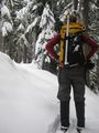
Given that there was only slightly more than 8 hours of daylight, time would definitely be a factor, so the daring duo of alpine adventurers set off in the wee hours of the morning. Several hours of driving later, they exited their vehicle, donned their winter boots, hoisted their packs and set off down the trail!
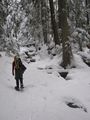
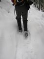
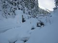
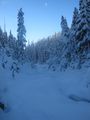
They first walked 2km to the snowed-in parking lot where the trail actually began. From there they began an endless (read: 6km) series of painful switchbacks that would carry them up the mountain. thepiguy quickly decided he was tired of carrying his snowshoes on his back and opted to put them on his feet. Weather this actually made walking easier, or just made his pack lighter, Jafo decided to follow suit. At this point the trees were dense and the snow compact, making for easy going. As they progressed upward the snow began to accumulate but thankfully there was a deep track worn in the trail by other recent hikers.
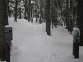
At the 6km marker the trail split in two with the left branch leading off to a camp ground and the right branch leading to the lake. Sadly, there had been little recent traffic to the lake and the trail was left untouched and buried under several feet of fresh snow. *sigh*
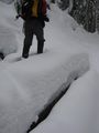
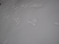
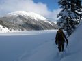
For the most part, the trail was still easy to follow, so they trudged on enjoying the untouched powder and the beautiful terrain. The path rolled up and down through the trees, over small bridges and next to a few smaller lakes. Occasionally they found themselves following animal tracks in the snow and figured that a small rabbit probably knew the trail better than they did anyway. Nearing the lake, the path made a few sharp turns and managed to free itself of the pair of persistent hikers. They were able to find the path again, but not before unknowingly crossing a large stream on a bridge made of snow, rather than the bridge made of wood and steel.
They found their way to a wooden shelter on the edge of the lake and collapsed onto a wooden bench in order to have a rest. thepiguy hopefully turned on his GPS in order to check the remaining distance to the hashpoint. He winced and let out a small cry of pain when a rather large number appeared on the display.
It was now almost 2:00pm, meaning only about 2 hours of daylight left, and seeing as they had started at 8:00am they would already be returning by dark. Fortunately for therpiguy, it was Jafo who was responsible for the sanity checks on this trip: Having traveled 11km thus far (and with their combined snowshoeing experience totaling a little over 22km --No, I didn't mess up the math--) it was probably for the best that they chose not to wander over 2km off of the trail into the wilderness.
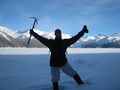
With the stresses of reaching the hash point now lifted, they were left with nothing else to do but rest, eat some lunch and admire the spectacular view!
Oh, they had to get back to their car too. But that only took another 5 hours.
Images
Crazy weather along the highway in the morning.

The first stop in any good Canadian geohash!
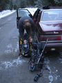
Getting ready to start!
Time to start!
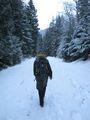
Up we go!
Straight ahead Capt'n!
The going gets tough.
Walking across a snow covered bridge.
Bunnies!
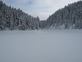
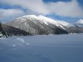
Encountering the first lake.
"I know there's a trail around here somewhere!"
A bridge we never ended up crossing.
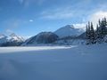
Walking along Garibaldi lake.
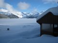
Finally a rest!
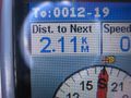
*Buzzer*
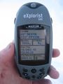
Recording our final location.
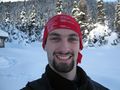
Still grin worthy!
Looking to the left, across the point.
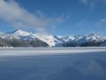
Looking directly across the lake.
Looking to the right, along the path we would have taken.
Save some of that energy for the trip home...
Heading back along our trail.
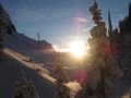
The setting sun. Good think we're over 3 hours from the car!
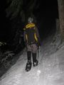
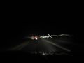
Walking back in pitch black!
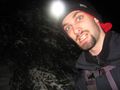
Very cold and very dark!


