Difference between revisions of "2010-10-16 42 -89"
imported>Bassoon (Created page with "{{subst:Expedition |lat = 42 |lon = -89 |date = 2010-10-16 }}") |
imported>Bassoon |
||
| Line 1: | Line 1: | ||
| − | |||
| − | |||
| − | |||
| − | |||
| − | |||
| − | |||
| − | |||
| − | |||
| − | |||
| − | |||
{{meetup graticule | {{meetup graticule | ||
| lat=42 | | lat=42 | ||
| Line 15: | Line 5: | ||
}} | }} | ||
| − | |||
| − | |||
== Location == | == Location == | ||
| − | + | A field (or so it was believed) in rural Wisconsin. Really, it wasn't close to any major city. | |
== Participants == | == Participants == | ||
| − | + | *[[User:Bassoon|Bassoon]] | |
| + | *[[user:Kuderererer|Kuderererer]] | ||
| + | *Jessie | ||
| + | *Mel | ||
== Plans == | == Plans == | ||
| − | + | Drive out to hash, explore, take photos, find food, come home. Standard hash fare. | |
== Expedition == | == Expedition == | ||
| − | + | We left around 15:00 and started the long drive out there. It was something like two hours, which is probably the second-longest amount of time we've traveled, right after the [[2010-08-13_44_-89|Wausau]] hash. It started out like every other west hash: I-94. | |
| + | |||
| + | We drove, and drove, and drove. Finally we pulled off the regular highway and started seeing things we didn't normally see back in the Fond du Lac graticule. Kettles and moraines, hills and valleys, cliffs and glens. It was beautiful. | ||
| + | |||
| + | We arrived at the side of the hash and found it...not a field. In fact, it wasn't even solid ground. It was a swamp. In the distance, we heard quiet pops. Oh...shit. Was it hunting season or something? | ||
| + | |||
| + | In a flurry, Bassoon threw open the back of his car and searched for orange-laden things. Mittens and hats and vests. Anything would do, as long as we didn't get shot. | ||
| + | |||
| + | We trudged out into the swamp. It smelled awful. Between fighting the thick muck and the oily water (which was absolutely disgusting--orange in some places!), we were fighting to get to the hash. And then we had to fight cattails and all sorts of swamp plants to get to the hash. Kuderererer grabbed a thistle as hard as he could on accident. Overall, we were cut, bruised, and battered when we reached the point. | ||
| + | |||
| + | After we were done in the swamp, we ran out of there was fast as we good, just to get back to the car, where we could get out of our wet shoes and our orange clothes. | ||
| + | |||
| + | Tradition dictates that we go to dinner after the hash. Unfortunately, the hash was in the middle of...well...nowhere. So we drove to the nearest city: Monroe. Now, this was really, really interesting, because Bassoon had a friend who lived out in Monroe. | ||
| − | + | We drove to Monroe and arrived after it was dark. Monroe is a really beautiful city! It had quite a thriving downtown area, which was especially charming. It reminded Bassoon and Kuderererer of the [[2010-07-05_43_-89|Baraboo]] hash. | |
| − | + | ||
| + | We wound up eating at a small sandwich place. Bassoon called his friend Sara and soon she met up with them too. They talked for awhile, but then it was time to go home. | ||
| + | |||
| + | The ride home was rather uneventful, until everyone almost died. There was this huge truck just parked across the highway in the darkness, so we didn't see it until it was almost too late to stop. If Jessie hadn't screamed, well, we would have all been dead. Woo! | ||
| + | |||
| + | Other than that, it was a great hash. A great way to spend one of the last nice days before the cold, unyielding Wisconsin winter. | ||
== Photos == | == Photos == | ||
| − | |||
| − | |||
| − | |||
<gallery perrow="5"> | <gallery perrow="5"> | ||
| + | Image:2010-10-16_42_-89_proof.png | We made it! After much tromping... | ||
| + | Image:2010-10-16_42_-89_victory.png | Here we are, in our disheveled, fluorescent orange glory. | ||
| + | Image:2010-10-16_42_-89_water.png | This is...water? No, it can't be! | ||
| + | Image:2010-10-16_42_-89_sunset.png | A beautiful sunset. | ||
</gallery> | </gallery> | ||
== Achievements == | == Achievements == | ||
{{#vardefine:ribbonwidth|800px}} | {{#vardefine:ribbonwidth|800px}} | ||
| − | + | {{land geohash | |
| + | | latitude = 42 | ||
| + | | longitude = -89 | ||
| + | | date = 2010-10-16 | ||
| + | | name = Bassoon, Jessie, Kuderererer, Mel | ||
| + | | image = 2010-10-16_42_-89_proof.png | ||
| + | }} | ||
| + | {{drag-along | ||
| + | | latitude = 42 | ||
| + | | longitude = -89 | ||
| + | | date = 2010-10-16 | ||
| + | | partner = Jessie and Mel | ||
| + | | name = Bassoon and Kuderererer | ||
| + | | image = 2010-10-16_42_-89_victory.png | ||
| + | }} | ||
| − | |||
| − | |||
| − | |||
| − | |||
| − | |||
| − | |||
| − | |||
| − | |||
| − | |||
| − | |||
| − | |||
[[Category:Expeditions]] | [[Category:Expeditions]] | ||
| − | |||
[[Category:Expeditions with photos]] | [[Category:Expeditions with photos]] | ||
| − | + | ||
| − | |||
| − | |||
| − | |||
| − | |||
[[Category:Coordinates reached]] | [[Category:Coordinates reached]] | ||
| − | |||
| − | |||
| − | |||
| − | |||
| − | |||
| − | |||
| − | |||
| − | |||
| − | |||
| − | |||
Revision as of 23:02, 16 January 2011
| Sat 16 Oct 2010 in 42,-89: 42.6937638, -89.8175575 geohashing.info google osm bing/os kml crox |
Location
A field (or so it was believed) in rural Wisconsin. Really, it wasn't close to any major city.
Participants
- Bassoon
- Kuderererer
- Jessie
- Mel
Plans
Drive out to hash, explore, take photos, find food, come home. Standard hash fare.
Expedition
We left around 15:00 and started the long drive out there. It was something like two hours, which is probably the second-longest amount of time we've traveled, right after the Wausau hash. It started out like every other west hash: I-94.
We drove, and drove, and drove. Finally we pulled off the regular highway and started seeing things we didn't normally see back in the Fond du Lac graticule. Kettles and moraines, hills and valleys, cliffs and glens. It was beautiful.
We arrived at the side of the hash and found it...not a field. In fact, it wasn't even solid ground. It was a swamp. In the distance, we heard quiet pops. Oh...shit. Was it hunting season or something?
In a flurry, Bassoon threw open the back of his car and searched for orange-laden things. Mittens and hats and vests. Anything would do, as long as we didn't get shot.
We trudged out into the swamp. It smelled awful. Between fighting the thick muck and the oily water (which was absolutely disgusting--orange in some places!), we were fighting to get to the hash. And then we had to fight cattails and all sorts of swamp plants to get to the hash. Kuderererer grabbed a thistle as hard as he could on accident. Overall, we were cut, bruised, and battered when we reached the point.
After we were done in the swamp, we ran out of there was fast as we good, just to get back to the car, where we could get out of our wet shoes and our orange clothes.
Tradition dictates that we go to dinner after the hash. Unfortunately, the hash was in the middle of...well...nowhere. So we drove to the nearest city: Monroe. Now, this was really, really interesting, because Bassoon had a friend who lived out in Monroe.
We drove to Monroe and arrived after it was dark. Monroe is a really beautiful city! It had quite a thriving downtown area, which was especially charming. It reminded Bassoon and Kuderererer of the Baraboo hash.
We wound up eating at a small sandwich place. Bassoon called his friend Sara and soon she met up with them too. They talked for awhile, but then it was time to go home.
The ride home was rather uneventful, until everyone almost died. There was this huge truck just parked across the highway in the darkness, so we didn't see it until it was almost too late to stop. If Jessie hadn't screamed, well, we would have all been dead. Woo!
Other than that, it was a great hash. A great way to spend one of the last nice days before the cold, unyielding Wisconsin winter.
Photos
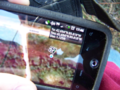
We made it! After much tromping...
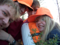
Here we are, in our disheveled, fluorescent orange glory.
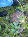
This is...water? No, it can't be!
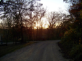
A beautiful sunset.


Achievements
Bassoon, Jessie, Kuderererer, Mel earned the Land geohash achievement
|
Bassoon and Kuderererer earned the Drag-along achievement
|