Difference between revisions of "2011-03-02 45 -121"
From Geohashing
imported>Jiml m (Fix images, prepare to appease APBot) |
imported>Jiml m (Adjust result codes) |
||
| Line 14: | Line 14: | ||
}} | }} | ||
| − | |||
__NOTOC__ | __NOTOC__ | ||
== Location == | == Location == | ||
| − | |||
In the Columbia Gorge. | In the Columbia Gorge. | ||
| Line 23: | Line 21: | ||
== Participants == | == Participants == | ||
| − | * | + | * [[User:kydlt|Dennis]] |
* my sweetheart Kate. | * my sweetheart Kate. | ||
== Plans == | == Plans == | ||
| − | |||
Not much of a plan, it was just a drive up the gorge. My bigger plan is learning to edit this wiki. | Not much of a plan, it was just a drive up the gorge. My bigger plan is learning to edit this wiki. | ||
== Expedition == | == Expedition == | ||
| − | + | Not reached. | |
| − | |||
| − | |||
| − | |||
== Photos == | == Photos == | ||
| − | + | <gallery perrow="3"> | |
| − | |||
| − | |||
| − | |||
| − | |||
| − | <gallery perrow=" | ||
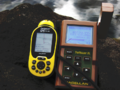
Image:2011-03-02 01real close.jpg | The DeLorme PN-20 that I am using now has mostly been used to log tracks to download to a laptop, so I am still learning the onboard interface. | Image:2011-03-02 01real close.jpg | The DeLorme PN-20 that I am using now has mostly been used to log tracks to download to a laptop, so I am still learning the onboard interface. | ||
image:2011-03-02 03old Magellen location.png | But I have played with GPS tech for a relative long time. Played being the operative word. | image:2011-03-02 03old Magellen location.png | But I have played with GPS tech for a relative long time. Played being the operative word. | ||
| Line 56: | Line 45: | ||
<!-- Add any achievement ribbons you earned below, or remove this section --> | <!-- Add any achievement ribbons you earned below, or remove this section --> | ||
| − | |||
| − | |||
| − | |||
| − | |||
| − | |||
| − | |||
| − | |||
| − | |||
| − | |||
| − | |||
| − | |||
| − | |||
| − | |||
| − | |||
| − | |||
| − | |||
| − | |||
| − | |||
| − | |||
| − | |||
| − | |||
| − | |||
| − | |||
| − | |||
| − | |||
| − | |||
| − | |||
| − | |||
| − | |||
| − | |||
[[Category:Expeditions]] | [[Category:Expeditions]] | ||
Revision as of 23:05, 23 July 2011
| Wed 2 Mar 2011 in 45,-121: 45.6620520, -121.0380045 geohashing.info google osm bing/os kml crox |
Location
In the Columbia Gorge.
Participants
- Dennis
- my sweetheart Kate.
Plans
Not much of a plan, it was just a drive up the gorge. My bigger plan is learning to edit this wiki.
Expedition
Not reached.
Photos
The DeLorme PN-20 that I am using now has mostly been used to log tracks to download to a laptop, so I am still learning the onboard interface.
But I have played with GPS tech for a relative long time. Played being the operative word.
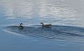
The geese are probably better at than I am.
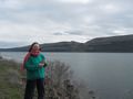
Kate is great.
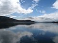
Roll on Columbia.
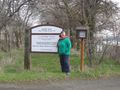
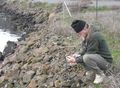
When I saw that today's geohash had a parking lot, how could I resist.


