Difference between revisions of "2011-03-09 45 -119"
imported>Kydlt |
imported>Mampfred (Lending a hand for cleanup => you used different names for the images when uploading and when including them here) |
||
| Line 1: | Line 1: | ||
| − | |||
| − | |||
| − | |||
| − | |||
| − | |||
| − | |||
| − | |||
| − | |||
{{meetup graticule | {{meetup graticule | ||
| lat=45 | | lat=45 | ||
| Line 13: | Line 5: | ||
}} | }} | ||
| − | |||
__NOTOC__ | __NOTOC__ | ||
== Location == | == Location == | ||
| Line 19: | Line 10: | ||
== Participants == | == Participants == | ||
| − | + | * [[User:Kydlt|Kydlt]] | |
| − | * [[User:Kydlt]] | ||
== Plans == | == Plans == | ||
| − | |||
From the userpage for [[User:Kydlt]] | From the userpage for [[User:Kydlt]] | ||
| Line 38: | Line 27: | ||
== Photos == | == Photos == | ||
| − | + | <gallery perrow="5"> | |
| − | + | Image:right here.JPG|The tumble weed missed me! | |
| − | + | Image:down there.jpg|Looking down from closest public approach. | |
| − | + | Image:nearest on road.jpg|Up on the road, 443 feet away. Be brave, go to the ranchhouse. | |
| − | + | Image:ask permission.jpg|Boy, did he think I was weird. | |
| − | + | Image:N.E.Oragon.jpg|Miles of miles. | |
| − | + | Image:butter creek crossing.jpg|Always stop for historical markers if possible. | |
| − | + | Image:Mt Hood maybe.jpg|Through the haze. I think that it is the rock and snow of Mt. Hood, not clouds. | |
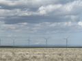
| − | + | Image:windmills.jpg|The new crop. | |
| − | + | Image:good mileage.jpg|OK, I did have a tailwind. | |
| − | + | </gallery> | |
| − | |||
| − | |||
| − | </gallery | ||
== Achievements == | == Achievements == | ||
| Line 57: | Line 43: | ||
<!-- Add any achievement ribbons you earned below, or remove this section --> | <!-- Add any achievement ribbons you earned below, or remove this section --> | ||
| − | |||
| − | |||
| − | |||
| − | |||
| − | |||
| − | |||
| − | |||
| − | |||
| − | |||
| − | |||
| − | |||
[[Category:Expeditions]] | [[Category:Expeditions]] | ||
| − | |||
[[Category:Expeditions with photos]] | [[Category:Expeditions with photos]] | ||
| − | |||
| − | |||
| − | |||
[[Category:Coordinates reached]] | [[Category:Coordinates reached]] | ||
| − | |||
| − | |||
| − | |||
| − | |||
| − | |||
| − | |||
| − | |||
| − | |||
| − | |||
| − | |||
Revision as of 14:49, 10 March 2011
| Wed 9 Mar 2011 in 45,-119: 45.5962276, -119.5374420 geohashing.info google osm bing/os kml crox |
Location
Participants
Plans
From the userpage for User:Kydlt
2011-03-09 Good drizzley morning. I found myself in Hermiston this morning so I think I will go on a little trip down to 45.596227°, -119.537443°.
Expedition
Events found me in Hermiston with no real plan for the day. The internet to the rescue ! A short drive away was the spot, and in a virgin graticule. There might be a dearth of nerds in Eastern Oregon. Struggling with my typical lack of social skills, I knocked on the door of a lonely ranchhouse. Being greeted by a an older gentleman whom was wearing a hubcap on his beltbuckle I strugled to explain myself. He got tired of hearing me talk and pointed me in the direction that I wished to go. He didn't want his photo on the internet, but his mailbox was ok with it. Let's see if I can post this correctly.
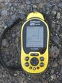
Tracklog
Photos
- Right here.JPG
The tumble weed missed me!
Looking down from closest public approach.
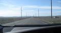
Up on the road, 443 feet away. Be brave, go to the ranchhouse.
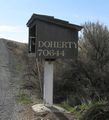
Boy, did he think I was weird.
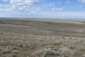
Miles of miles.
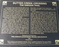
Always stop for historical markers if possible.
Through the haze. I think that it is the rock and snow of Mt. Hood, not clouds.
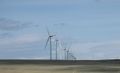
The new crop.
OK, I did have a tailwind.


