Difference between revisions of "2011-03-15 48 5"
From Geohashing
imported>Jiml m (Clean up for result codes) |
imported>FippeBot m (Location) |
||
| Line 65: | Line 65: | ||
[[Category:Expeditions with photos]] | [[Category:Expeditions with photos]] | ||
[[Category:Coordinates reached]] | [[Category:Coordinates reached]] | ||
| + | {{location|FR|88}} | ||
Revision as of 03:52, 6 August 2019
| Tue 15 Mar 2011 in 48,5: 48.2336985, 5.7853937 geohashing.info google osm bing/os kml crox |
Location
A forest less then 5 km from the A21 between Nancy and Dijon
Participants
Plans
I'm attending a meeting in Grenoble, and this hash is more or less on the way, so...
Expedition
I enjoyed a beautiful sunset whilst eating a sandwich at a highway rest stop some 40 km north of the hash, thus I had to run into a dark forest at night once again. Even the moonlight wasn't sufficient enough, but that's nothing a little flashlight can't solve.
The GPS led me over a little hill with badger holes, and then downwards crossing a swampy stream. I crossed the stream, walked a few more meters et voila: coordinates reached!
And also: first hash in this graticule!
Tracklog

Photos
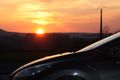
sunset during 'dinner'
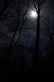
full moon / dark forest
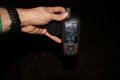
the hash!


Achievements
- Land Geohash