Difference between revisions of "2011-04-04 41 24"
From Geohashing
imported>Kisolre (Created page with "{{subst:Expedition |lat = 41 |lon = 24 |date = 2011-04-04 }}") |
imported>Kisolre |
||
| Line 1: | Line 1: | ||
| − | |||
| − | |||
| − | |||
| − | |||
| − | |||
| − | |||
| − | |||
| − | |||
| − | |||
| − | |||
{{meetup graticule | {{meetup graticule | ||
| lat=41 | | lat=41 | ||
| Line 18: | Line 8: | ||
__NOTOC__ | __NOTOC__ | ||
== Location == | == Location == | ||
| − | + | Near [http://bg.wikipedia.org/wiki/%D0%A1%D1%82%D0%BE%D0%BC%D0%B0%D0%BD%D0%B5%D0%B2%D0%BE Stomanevo] village. | |
== Participants == | == Participants == | ||
| − | + | [[user:kisolre|Kisolre]] and Vania (almost to the point... again :) ) | |
| − | |||
| − | |||
| − | |||
== Expedition == | == Expedition == | ||
| − | + | We were on vacation so visiting strange places is part of the un :). It was a long mountain driving but at the end the weather and the fresh mountain air were very nice. Tha hash was on the very steep slope and vania did not like it so she stayed at the top. There was a flock of sheep at he field. The GPS was very jumpy so I was wandering around trying to pinpoint the hash for the amusement of Vania and the shepherd :) | |
| − | |||
| − | |||
| − | |||
== Photos == | == Photos == | ||
| Line 36: | Line 20: | ||
Image:2010-##-## ## ## Alpha.jpg | Witty Comment | Image:2010-##-## ## ## Alpha.jpg | Witty Comment | ||
--> | --> | ||
| − | <gallery perrow=" | + | <gallery perrow="3"> |
| + | Image:2011-04-04_41_24_Field.jpg | A field at a very steep slope | ||
| + | Image:2011-04-04_41_24_V.jpg | Vania at the top | ||
| + | Image:2011-04-04_41_24_Sheep.jpg | A flock of sheep | ||
| + | Image:2011-04-04_41_24_Proof.jpg | Proof | ||
| + | Image:2011-04-04_41_24_Kisolre.jpg | Me at the hash | ||
</gallery> | </gallery> | ||
| Line 42: | Line 31: | ||
{{#vardefine:ribbonwidth|800px}} | {{#vardefine:ribbonwidth|800px}} | ||
<!-- Add any achievement ribbons you earned below, or remove this section --> | <!-- Add any achievement ribbons you earned below, or remove this section --> | ||
| + | {{Virgin graticule | ||
| + | | latitude = 41 | ||
| + | | longitude = 24 | ||
| + | | date = 2011-04-04 | ||
| + | | name = [[user:kisolre|Kisolre]] | ||
| + | | image = 2011-03-21_41_24_Kisolre.jpg | ||
| + | }} | ||
| + | {{Minesweeper geohash | ||
| + | | graticule = Plovdiv, Bulgaria | ||
| + | | ranknumber = 1 | ||
| + | | s = true if graticule to the south has been hashed (optional) | ||
| + | | name = [[user:kisolre|Kisolre]] | ||
| + | }} | ||
| − | |||
| − | |||
| − | |||
| − | |||
| − | |||
| − | |||
| − | |||
| − | |||
| − | |||
| − | |||
| − | |||
[[Category:Expeditions]] | [[Category:Expeditions]] | ||
| − | |||
[[Category:Expeditions with photos]] | [[Category:Expeditions with photos]] | ||
| − | |||
| − | |||
| − | |||
| − | |||
| − | |||
[[Category:Coordinates reached]] | [[Category:Coordinates reached]] | ||
| − | |||
| − | |||
| − | |||
| − | |||
| − | |||
| − | |||
| − | |||
| − | |||
| − | |||
| − | |||
Revision as of 17:51, 4 April 2011
| Mon 4 Apr 2011 in 41,24: 41.8004297, 24.4244811 geohashing.info google osm bing/os kml crox |
Location
Near Stomanevo village.
Participants
Kisolre and Vania (almost to the point... again :) )
Expedition
We were on vacation so visiting strange places is part of the un :). It was a long mountain driving but at the end the weather and the fresh mountain air were very nice. Tha hash was on the very steep slope and vania did not like it so she stayed at the top. There was a flock of sheep at he field. The GPS was very jumpy so I was wandering around trying to pinpoint the hash for the amusement of Vania and the shepherd :)
Photos
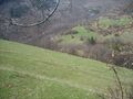
A field at a very steep slope
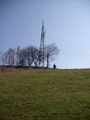
Vania at the top
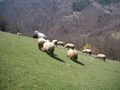
A flock of sheep
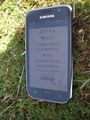
Proof

Me at the hash


Achievements
Kisolre achieved level 1 of the Minesweeper Geohash achievement
|