Difference between revisions of "2011-04-18 50 12"
From Geohashing
imported>Reinhard (mini report) |
imported>FippeBot m (Location) |
||
| Line 26: | Line 26: | ||
[[Category:Expeditions with photos]] | [[Category:Expeditions with photos]] | ||
[[Category:Coordinates reached]] | [[Category:Coordinates reached]] | ||
| + | {{location|DE|TH|G}} | ||
Latest revision as of 03:58, 6 August 2019
| Mon 18 Apr 2011 in 50,12: 50.9074438, 12.0279540 geohashing.info google osm bing/os kml crox |
Location
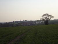
On a field between Thieschitz and Hartmannsdorf near Gera, Thuringia.
Participants
Expedition
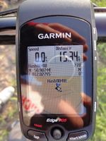
Reinhard was driving to Leipzig after work and hopped out of the car in Kraftsdorf to start a short (36 km) bike trip in the warming evening sun. The hashpoint was 60 m into a field, but since it was dry and a pair of tractor tracks lead directly to the spot, he could easily reach it. Nothing else important to mention.
Photos
|


