Difference between revisions of "2011-05-21 40 -74"
imported>Jevanyn ([retro picture] Based on which way the numbers face, it's 15 miles to Trenton, and 28 miles to New Brunswick YMMV.) |
imported>Jiml m (Adjust result codes) |
||
| Line 29: | Line 29: | ||
== Expedition == | == Expedition == | ||
| − | + | ||
| Line 35: | Line 35: | ||
Not knowing the lay of the land (GPS malfunctioning until after I got to the trailhead) I ended up parked about a mile from the canal. It started to rain just as I headed back. -- [[User:Jevanyn|Jevanyn]] 03:31, 22 May 2011 (EDT) | Not knowing the lay of the land (GPS malfunctioning until after I got to the trailhead) I ended up parked about a mile from the canal. It started to rain just as I headed back. -- [[User:Jevanyn|Jevanyn]] 03:31, 22 May 2011 (EDT) | ||
| + | |||
== Tracklog == | == Tracklog == | ||
<!-- if your GPS device keeps a log, you may post a link here --> | <!-- if your GPS device keeps a log, you may post a link here --> | ||
== Photos == | == Photos == | ||
| − | + | ||
| − | |||
| − | |||
<gallery perrow="5"> | <gallery perrow="5"> | ||
| Line 70: | Line 69: | ||
{{#vardefine:ribbonwidth|800px}} | {{#vardefine:ribbonwidth|800px}} | ||
<!-- Add any achievement ribbons you earned below, or remove this section --> | <!-- Add any achievement ribbons you earned below, or remove this section --> | ||
| + | |||
| + | * Land geohash | ||
| − | |||
| − | |||
[[Category:Expeditions]] | [[Category:Expeditions]] | ||
| − | + | ||
[[Category:Expeditions with photos]] | [[Category:Expeditions with photos]] | ||
| − | + | ||
| − | |||
| − | |||
| − | |||
| − | |||
[[Category:Coordinates reached]] | [[Category:Coordinates reached]] | ||
| − | |||
| − | |||
| − | |||
| − | |||
| − | |||
| − | |||
| − | |||
| − | |||
| − | |||
| − | |||
Revision as of 09:32, 22 May 2011
| Sat 21 May 2011 in 40,-74: 40.3363335, -74.6496377 geohashing.info google osm bing/os kml crox |
Location
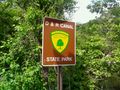
D & R Canal path, in Princeton Township. The tow path on the east side of the canal is the dividing line between Princeton and West Windsor Township [1], so the margin for error overlaps the border.
Participants
- Jevanyn will try to make it at 4PM, time is somewhat flexible, and I may be bringing Evan and/or other dragalongs.
Plans
- Jevanyn: I've been in the area a hundred times, as 206 is my regular route to Cape May. I can't make it in the morning, but I'm going to make an effort to be there if there is a meetup.
Also of interest
The Berlin meetup is a 4PM European time, which is 10AM here.
Expedition
- Feh. Google Maps lied; there was no trail on the east side of the canal. Starting from Alexander Rd., a short gravely path leads to a fenced off power station just before the train line. Beyond the train tracks is a grassy way, but it was flooded in places. I made the closest approach possible on the opposite side of the canal. If I'd come earlier, and if there had been more people (ahem) I could have rented a canoe and gotten closer, but I was (briefly) within the margin of error for my GPS.
Not knowing the lay of the land (GPS malfunctioning until after I got to the trailhead) I ended up parked about a mile from the canal. It started to rain just as I headed back. -- Jevanyn 03:31, 22 May 2011 (EDT)
Tracklog
Photos
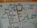
Shockingly, this map was useful.
Students: no left turn
After a mile hike downhill....
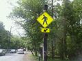
Pedestrian-activated warning lights at crossing, 3 to 5 times more effective than wildly waving your arms
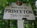
Princeton welcomes you! Please wipe your feet
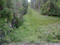
Do you see a trail here? I see flooding and a natural gas pipeline.
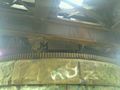
It's not a drawbridge, but the rail crossing has some sort of works underneath.
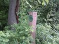
The geohash

A geohasher
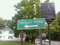
Either 10 miles of half a mile from something more interesting
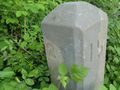
Based on which way the numbers face, it's 15 miles to Trenton, and 28 miles to New Brunswick YMMV.


Achievements
- Land geohash