Difference between revisions of "2011-05-22 45 -121"
imported>Jiml m (Adjust result codes) |
imported>Jiml m (MNB Ribbon??) |
||
| Line 53: | Line 53: | ||
{{#vardefine:ribbonwidth|800px}} | {{#vardefine:ribbonwidth|800px}} | ||
| − | + | * MNB?? | |
| − | |||
| − | |||
| − | |||
| − | |||
| − | |||
Revision as of 04:57, 23 May 2011
| Sun 22 May 2011 in 45,-121: 45.6495345, -121.5661950 geohashing.info google osm bing/os kml crox |
Location
Tucker County Park, South of the town of Hood River.
Participants
Plans
Going by myself. I plan to be there 1200 or 1300 & stay a little while.
Expedition
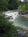
I had a nice drive, and it WAS sunny in Hood River. But Gooogle lied, the hash was in or just across the Hood River. My GPS calculated it as 30 m. away from me. It was private property on the other side, and the river was too fast, high and cold to wade today.
So a near miss, defeated again by the Northwest's wonderful, plentiful water. But I checked out a nice county park and bought some atlatal darts at Good Karma.
Tracklog
I have the log, now to figure out how to link to it.
Photos
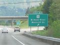
Rolling into Hood River.
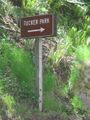
about 4 mi to Tucker Park.
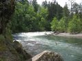
The hash was just at the river's curve, but on the other side.
I was above the trees on a cliff about 30 m. away.
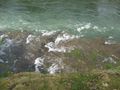
And about 10 m. straight down.
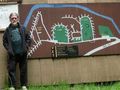
But I got to check out a nice little park to take the children camping to this summer.
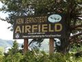
I passed the airport coming and going.

But the sailplane's wings were off. The sign is the plane's road case.

This is a GREAT museum!
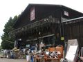
And I always stop in here to get great stuff.
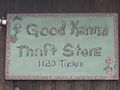
No relation or affiliation. Other than he holds stuff for me when he thinks I need it.


Achievements
- MNB??