Difference between revisions of "2011-05-29 31 34"
From Geohashing
imported>Jiml m (Uncomnent result codes) |
imported>FippeBot m (Location) |
||
| Line 48: | Line 48: | ||
[[Category:Expeditions with photos]] | [[Category:Expeditions with photos]] | ||
[[Category:Coordinates reached]] | [[Category:Coordinates reached]] | ||
| + | {{location|IL|D|AS}} | ||
Latest revision as of 12:30, 14 July 2019
| Sun 29 May 2011 in 31,34: 31.5979576, 34.8216042 geohashing.info google osm bing/os kml crox |
Location
The hash landed in a field close to Kiryat Gat, near road 6 and road 35 interchange.
Participants
Plans
I was on the road and had a couple of hours to spare.
Expedition
Took a small detour on my way from Jerusalem to Tel-Aviv. I drove though the beautiful landscape on road 38 and 35, until i reached a small natural reserve. After spending some time getting lost in the woods I reached the spot around 13:45. I took a couple of moments to relax in the sun took a couple of photos and was on my way.
Photos
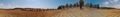
Hashpoint view
Achievements
pseudoDust earned the Land geohash achievement
|