Difference between revisions of "Peoria, Illinois/Land Usage"
imported>Dvdllr m (date correction) |
imported>Dvdllr m (typo) |
||
| Line 16: | Line 16: | ||
|Yellow | |Yellow | ||
|farms/crop fields | |farms/crop fields | ||
| − | | | + | |4104 |
|70.08% | |70.08% | ||
|- | |- | ||
Revision as of 15:32, 12 December 2014
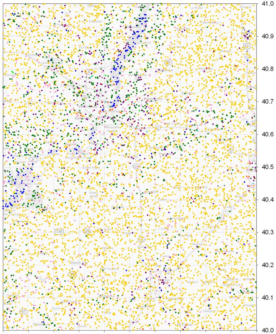
After having finished the Regional Geohash maps for the 50 United States, I thought about the next big thing I could work on. I was intrigued by the Land usage code that some graticules used to map out what's in their area. Instead of going that way, I decided to do a more empirical approach, and see where the geohashes have fallen in the Peoria graticule since 2000-01-01. I worked on and off over about a year to look individually at each daily geohash (>4000 days for the initial 11 years), and log the coordinates and what type of land it was. I organized everything in an Excel spreadsheet and graphed the results, seen below.
After completing everything from 2000 to present, I continued to maintain the log daily, but didn't attempt to go further back in history for another year and a half or so. What I am doing now is that every week, I'll log another month of historical dates for this graticule into the map. As of this writing I have been doing it for about 24 weeks so I have completed all of 1998 to present. I intend to update the map online annually. Since the DJIA goes back to 1928-10-01, and I can complete 52 months a year, I ought to be done in about 16 years or so (assuming I still live in this graticule by then). Dvdllr 11:27, 10 January 2014 (EST)
As of 2014-01-10, there have been 5856 locations since 1998-01-01.
Color key, in descending order of frequency:
| Color | Type | Count | Percent |
|---|---|---|---|
| Yellow | farms/crop fields | 4104 | 70.08% |
| Dark green | forests/woods | 668 | 11.41% |
| Pink | grass/dirt/open space | 455 | 7.77% |
| Purple | residential property | 261 | 4.46% |
| Blue | water | 163 | 2.78% |
| Grey | roads | 94 | 1.61% |
| Orange | businesses | 77 | 1.31% |
| Red | schools/colleges | 10 | 0.17% |
| Aqua | parking lots | 8 | 0.14% |
| Bright green | golf courses | 7 | 0.12% |
| Black | railroads | 5 | 0.09% |
| Brown | cemeteries | 4 | 0.07% |
