Difference between revisions of "2011-07-01 -37 144"
From Geohashing
imported>Taner (Created page with "{{meetup graticule | lat=-37 | lon=144 | date=2011-07-01 }} == Location == A plot of land on Boadles Ln in Little River == Who went == * Taner ==Expedition== *...") |
imported>Taner m (Broken image link) |
||
| Line 26: | Line 26: | ||
Image:2011-07-01 -37 144 GPS.JPG|GPS in hand | Image:2011-07-01 -37 144 GPS.JPG|GPS in hand | ||
Image:2011-07-01 -37 144 Surroundings.JPG|Surroundings | Image:2011-07-01 -37 144 Surroundings.JPG|Surroundings | ||
| − | Image:2011-07-01 -37 144 Flash. | + | Image:2011-07-01 -37 144 Flash.JPG|Flash |
</gallery> | </gallery> | ||
[[Category:Expeditions]] | [[Category:Expeditions]] | ||
[[Category:Coordinates reached]] | [[Category:Coordinates reached]] | ||
Revision as of 11:29, 3 July 2011
| Fri 1 Jul 2011 in -37,144: -37.9529964, 144.5149988 geohashing.info google osm bing/os kml crox |
Contents
Location
A plot of land on Boadles Ln in Little River
Who went
Expedition
Nothing special about this one unlike the one on Wednesday. Happened to be a 5 minute detour away from my drive to Wye River for the weekend.
Had to jump over a fence again but at least I wasn't camping on someone's property this time!
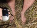
I'd like to say it was deliberate but my visit was coincided with two train passing so there is something to look at in the photos. And also, due to laziness, I didn't put on my shoes for the short walk from the car, found a Hobbit achievement but I think my 200m walk falls short of the mark!
Photos
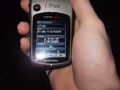
GPS in hand

Surroundings
Flash


