Difference between revisions of "2011-07-06 44 -107"
imported>JesseW (restore the map image, and location; add a minimal explanatory note that the rest was removed by request of the original author) |
imported>Tankgunk (Un-blanking the page. I was, er, having a bad year -_-) |
||
| Line 1: | Line 1: | ||
| + | [[Image:{{{image|2011-07-06_44_-107_overthere.jpg}}}|thumb|left]] | ||
| + | |||
{{meetup graticule | {{meetup graticule | ||
| lat=44 | | lat=44 | ||
| Line 8: | Line 10: | ||
== Location == | == Location == | ||
Less than half a mile off a road in the Bighorn National Forest. | Less than half a mile off a road in the Bighorn National Forest. | ||
| + | |||
| + | == Participants == | ||
| + | [[User:Tankgunk|Tankgunk]] and his sister. | ||
== Plans == | == Plans == | ||
| − | ''' | + | We drove up into the forest after work and gave it a shot. This time we took a (slightly) better camera and went during daylight, so the pictures are actually worth something. |
| + | |||
| + | == Expedition == | ||
| + | It was about a half hour drive to the edge of the forest, and then another hour long drive to the "road closed" sign on Forest Route 227. Spent a bit of time backtracking, and ended up driving down a larger road to the head of Forest Route 226. About 2000ft from the hash point, we left the car on the other side of a stream and headed out along the road on foot. Fooled around with the camera, took pictures of the stream running along the road, etc. About the time when we were right across from the hash point, we realized that we couldn't cross the stream safely. It looks tiny on all the maps and satellite imagery I'd looked at, and it isn't terribly wide, but it was rather deep and rather swift. We could have gotten around it at a fork near the spot where we parked, but it would have taken too long; we were out of daylight. Still had fun though, and we got some cool pictures while we were driving home. | ||
| + | |||
| + | == Photos == | ||
| + | <gallery perrow="5"> | ||
| + | File:2011-07-06_44_-107_map.png | Planned route in red, actual route in orange. | ||
| + | File:2011-07-06_44_-107_closed.jpg | Why we didn't take Forest Route 227... | ||
| + | File:2011-07-06_44_-107_stream.jpg | Where we started on foot, about 2000ft from the point. | ||
| + | File:2011-07-06_44_-107_fording.jpg | Fording the stream. | ||
| + | File:2011-07-06_44_-107_cold.jpg | "Hurry and take the picture, it's freaking cold!" | ||
| + | File:2011-07-06_44_-107_startofwalk.jpg | After crossing the stream. | ||
| + | File:2011-07-06_44_-107_flipflop.jpg | "Hold on, there's something in my flip flop." | ||
| + | File:2011-07-06_44_-107_goofing.jpg | Playing with the camera. | ||
| + | File:2011-07-06_44_-107_hellostream.jpg | Ohai stream! | ||
| + | File:2011-07-06_44_-107_thumbsup.jpg | Giving the stream a thumbs up. | ||
| + | File:2011-07-06_44_-107_roadblocked.jpg | Just over 1200ft from the point now. | ||
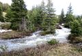
| + | File:2011-07-06_44_-107_overthere.jpg | Where the point was, about 300ft over. | ||
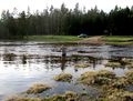
| + | File:2011-07-06_44_-107_morewater.jpg | Still taking pictures of the stream. | ||
| + | File:2011-07-06_44_-107_itsfast.jpg | And then we realized we weren't equipped to cross it >.< | ||
| + | File:2011-07-06_44_-107_majesty.jpg | Driving back out, found this funny. Dunno why. | ||
| + | File:2011_07_06_44_-107_sunset.jpg | Awesome sunset under the storm clouds. | ||
| + | File:2011-07-06_44_-107_clouds.jpg | Thought these clouds were awesome. They kinda aren't. | ||
| + | File:2011-07-06_44_-107_moresunset.jpg | My favorite picture from the whole thing. | ||
| + | File:2011-07-06_44_-107_windingroad.jpg | Just driving home... | ||
| + | </gallery> | ||
| + | |||
| + | == Achievements == | ||
| + | {{#vardefine:ribbonwidth|800px}} | ||
| + | {{mnb geohash | ||
| + | | latitude = 44 | ||
| + | | longitude = -107 | ||
| + | | date = 2011-07-06 | ||
| + | | name = tankgunk | ||
| + | }} | ||
| + | |||
| + | {{My kingdom for a boat | ||
| + | | latitude = 44 | ||
| + | | longitude = -107 | ||
| + | | date = 2011-07-06 | ||
| + | | name = tankgunk | ||
| + | | waterhazard = scary stream | ||
| + | }} | ||
[[Category:Expeditions]] | [[Category:Expeditions]] | ||
| + | [[Category:Expeditions with photos]] | ||
[[Category:Coordinates not reached]] | [[Category:Coordinates not reached]] | ||
[[Category:Not reached - Mother Nature]] | [[Category:Not reached - Mother Nature]] | ||
Revision as of 07:41, 11 January 2013

| Wed 6 Jul 2011 in 44,-107: 44.6230991, -107.4071567 geohashing.info google osm bing/os kml crox |
Location
Less than half a mile off a road in the Bighorn National Forest.
Participants
Tankgunk and his sister.
Plans
We drove up into the forest after work and gave it a shot. This time we took a (slightly) better camera and went during daylight, so the pictures are actually worth something.
Expedition
It was about a half hour drive to the edge of the forest, and then another hour long drive to the "road closed" sign on Forest Route 227. Spent a bit of time backtracking, and ended up driving down a larger road to the head of Forest Route 226. About 2000ft from the hash point, we left the car on the other side of a stream and headed out along the road on foot. Fooled around with the camera, took pictures of the stream running along the road, etc. About the time when we were right across from the hash point, we realized that we couldn't cross the stream safely. It looks tiny on all the maps and satellite imagery I'd looked at, and it isn't terribly wide, but it was rather deep and rather swift. We could have gotten around it at a fork near the spot where we parked, but it would have taken too long; we were out of daylight. Still had fun though, and we got some cool pictures while we were driving home.
Photos
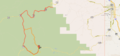
Planned route in red, actual route in orange.
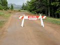
Why we didn't take Forest Route 227...
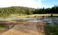
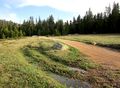
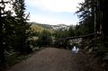
Where we started on foot, about 2000ft from the point.
Fording the stream.
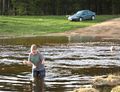
"Hurry and take the picture, it's freaking cold!"
After crossing the stream.
"Hold on, there's something in my flip flop."

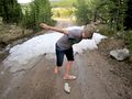
Playing with the camera.
Ohai stream!
Giving the stream a thumbs up.
Just over 1200ft from the point now.
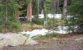
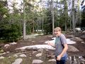
Where the point was, about 300ft over.
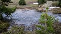
Still taking pictures of the stream.
And then we realized we weren't equipped to cross it >.<
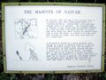
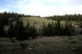
Driving back out, found this funny. Dunno why.
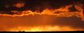
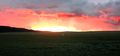
Awesome sunset under the storm clouds.
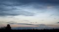
Thought these clouds were awesome. They kinda aren't.
My favorite picture from the whole thing.
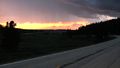
Just driving home...


Achievements
tankgunk earned the My kingdom for a boat consolation prize
|