Difference between revisions of "2011-07-18 55 13"
imported>Fasanen (Created page with "{{subst:Expedition |lat = 55 |lon = 13 |date = 2011-07-18 }}") |
imported>Fasanen (New expedition) |
||
| Line 1: | Line 1: | ||
| − | |||
| − | |||
| − | |||
| − | |||
| − | |||
| − | |||
| − | |||
| − | |||
| − | |||
| − | |||
{{meetup graticule | {{meetup graticule | ||
| lat=55 | | lat=55 | ||
| Line 14: | Line 4: | ||
| date=2011-07-18 | | date=2011-07-18 | ||
}} | }} | ||
| − | |||
| − | |||
__NOTOC__ | __NOTOC__ | ||
== Location == | == Location == | ||
| − | + | Sparse forest next to "Skåne leden", northern Häckeberga. | |
== Participants == | == Participants == | ||
| − | + | * [[User:Fasanen|Fasanen]] | |
== Plans == | == Plans == | ||
| − | + | No particular. | |
== Expedition == | == Expedition == | ||
| − | + | Today’s geohash location was a convenient one; a short cut on my way home from work if not for the inferior road conditions through the northern parts of the Häckeberga. The coordinates were in sparse forest next to “Skåne leden” (Skåne trail), a 1000 kilometer long walking trail around the Scania province. | |
| − | + | The approach to the geohash was a bit rough as a piece of swamp had to be crossed but I managed getting through it without getting my sneakers wet. The actual geohash spot was a surprisingly pleasant one. I marked it XKCD with some branches and took some photographs of flora and fauna before heading home where pancakes got served. | |
| − | |||
== Photos == | == Photos == | ||
| − | < | + | <gallery perrow="4"> |
| − | Image: | + | Image:201107185513 04.JPG |180 view |
| − | + | Image:201107185513 05.JPG |XKCD@geohash | |
| − | + | Image:201107185513 06.JPG |View from hash | |
| + | Image:201107185513 07.JPG |Me | ||
| + | Image:201107185513 08.JPG |Stone wall next to geohash | ||
| + | Image:201107185513 09.JPG |Rowanberries | ||
| + | Image:201107185513 10.JPG |Ants busy collecting some juicy stuff | ||
| + | Image:201107185513 11.JPG |Snail posing for the camera | ||
| + | Image:201107185513 12.JPG |Mushroom | ||
| + | Image:201107185513 13.JPG |Another mushroom | ||
| + | Image:201107185513 14.JPG |Skåne trail | ||
| + | Image:201107185513 15.JPG |Proof | ||
</gallery> | </gallery> | ||
== Achievements == | == Achievements == | ||
{{#vardefine:ribbonwidth|800px}} | {{#vardefine:ribbonwidth|800px}} | ||
| − | + | {{land geohash | latitude=55 | longitude=13 | date=2011-07-18 | name=Fasanen}} | |
| − | |||
| − | |||
| − | |||
| − | |||
| − | |||
| − | |||
| − | |||
| − | |||
| − | |||
| − | |||
| − | |||
[[Category:Expeditions]] | [[Category:Expeditions]] | ||
| − | |||
[[Category:Expeditions with photos]] | [[Category:Expeditions with photos]] | ||
| − | |||
| − | |||
| − | |||
| − | |||
| − | |||
[[Category:Coordinates reached]] | [[Category:Coordinates reached]] | ||
| − | + | [[Category:Sweden]] | |
| − | |||
| − | |||
| − | |||
| − | |||
| − | |||
| − | |||
| − | |||
| − | [[Category: | ||
| − | |||
Revision as of 18:17, 20 July 2011
| Mon 18 Jul 2011 in 55,13: 55.6128470, 13.4626463 geohashing.info google osm bing/os kml crox |
Location
Sparse forest next to "Skåne leden", northern Häckeberga.
Participants
Plans
No particular.
Expedition
Today’s geohash location was a convenient one; a short cut on my way home from work if not for the inferior road conditions through the northern parts of the Häckeberga. The coordinates were in sparse forest next to “Skåne leden” (Skåne trail), a 1000 kilometer long walking trail around the Scania province.
The approach to the geohash was a bit rough as a piece of swamp had to be crossed but I managed getting through it without getting my sneakers wet. The actual geohash spot was a surprisingly pleasant one. I marked it XKCD with some branches and took some photographs of flora and fauna before heading home where pancakes got served.
Photos
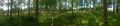
180 view
XKCD@geohash
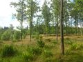
View from hash

Me
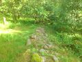
Stone wall next to geohash
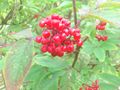
Rowanberries
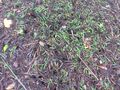
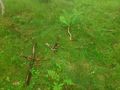
Ants busy collecting some juicy stuff
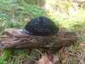
Snail posing for the camera
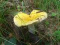
Mushroom
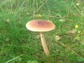
Another mushroom
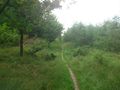
Skåne trail
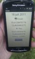
Proof


Achievements
Fasanen earned the Land geohash achievement
|