Difference between revisions of "2011-07-26 53 10"
From Geohashing
imported>Bierhefe (created page) |
imported>Bierhefe (cleaning up, adding pictures, adding gratuitous ribbon) |
||
| Line 1: | Line 1: | ||
| − | |||
| − | |||
| − | |||
| − | |||
| − | |||
| − | |||
| − | |||
| − | |||
| − | |||
{{meetup graticule | {{meetup graticule | ||
| lat=53 | | lat=53 | ||
| Line 15: | Line 6: | ||
}} | }} | ||
| − | |||
__NOTOC__ | __NOTOC__ | ||
== Location == | == Location == | ||
| Line 30: | Line 20: | ||
== Tracklog == | == Tracklog == | ||
| − | + | Tracklog on [http://www.everytrail.com/view_trip.php?trip_id=1221046 everytrail]. Note that the rest of the tracklog is for the [[2011-08-02 53 10]] hash point. The retro hash was reached after about 16km. | |
== Photos == | == Photos == | ||
| − | |||
| − | |||
| − | |||
<gallery perrow="5"> | <gallery perrow="5"> | ||
| + | Image:2011-08-02-003.jpg | Retro hash point | ||
| + | Image:2011-08-02-005.jpg | Coordinates... | ||
| + | Image:2011-08-02-004.jpg | reached! | ||
| + | Image:2011-08-02-007.jpg | Needed 55 minutes... | ||
| + | Image:2011-08-02-008.jpg | for 16km. Not the fastest bike around. :( | ||
</gallery> | </gallery> | ||
== Achievements == | == Achievements == | ||
{{#vardefine:ribbonwidth|800px}} | {{#vardefine:ribbonwidth|800px}} | ||
| − | + | {{gratuitous ribbon | |
| + | |color=red | ||
| + | |latitude=53 | ||
| + | |longitude=10 | ||
| + | |date=2011-08-02 | ||
| + | |name=[[User:Bierhefe|Bierhefe]] | ||
| + | |achievement=Multihash achievement (variant) | ||
| + | |description=reaching a retro geohash on the same expedition as reaching the | ||
| + | |icon=Minesweeper geohash 2.png | ||
| + | }} | ||
[[Category:New report]] | [[Category:New report]] | ||
[[Category:Coordinates reached]] | [[Category:Coordinates reached]] | ||
Revision as of 18:05, 3 August 2011
| Tue 26 Jul 2011 in 53,10: 53.4899497, 10.4334210 geohashing.info google osm bing/os kml crox |
Location
On a field near Brunstorf
Participants
Bierhefe
Plans
Stopping here on my way to the 2011-08-02 hash point.
Retro Expedition
While I was cycling to the hash point mentioned above I took a very small detour to visit this past hash point. Since I was around here anyway I figured this would be a good opportunity for a retro hash.
Tracklog
Tracklog on everytrail. Note that the rest of the tracklog is for the 2011-08-02 53 10 hash point. The retro hash was reached after about 16km.
Photos
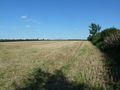
Retro hash point
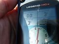
Coordinates...
reached!
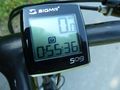
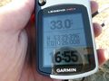
Needed 55 minutes...
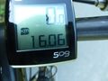
for 16km. Not the fastest bike around. :(


Achievements
Bierhefe earned the Multihash achievement (variant)
|