Difference between revisions of "2011-08-05 33 -84"
From Geohashing
imported>NWoodruff (Created page with "{{meetup graticule | map=<map lat="33" lon="-84" date="2011-08-05" /> | lat=33 | lon=-84 | date=2011-08-05 | graticule_name=Atlanta | graticule_link=Atlanta, Georgia }} == Grat...") |
imported>NWoodruff (→Gallery) |
||
| Line 23: | Line 23: | ||
== Gallery == | == Gallery == | ||
<gallery perrow="3"> | <gallery perrow="3"> | ||
| − | Image:2011080533-84NW01.JPG | + | Image:2011080533-84NW01.JPG | 480 feet from where I parked my truck. |
| + | Image:2011080533-84NW02.JPG | The bridge in the distance is GA400. | ||
| + | Image:2011080533-84NW03.JPG | I am now underneath GA400 looking up to the gap between the highway. | ||
| + | Image:2011080533-84NW04.JPG | 51 feet to go from the top of the bridge in between the gap. | ||
| + | Image:2011080533-84NW05.JPG | Looking at the northbound lane of traffic of GA400 standing at the top of the bridge. | ||
| + | Image:2011080533-84NW06.JPG | 10 feet to go. Close enough. | ||
| + | Image:2011080533-84NW07.JPG | Time of the meetup. | ||
| + | Image:2011080533-84NW08.JPG | Date of the meetup. | ||
| + | Image:2011080533-84NW09.JPG | 16 feet accuracy. I'm well within the 10 meters. | ||
| + | Image:2011080533-84NW10.JPG | A look at the Southbound lane of GA400, standing on the Geohash spot. | ||
| + | Image:2011080533-84NW11.JPG | Northbound lane of traffic with me standing on the Geohash spot. | ||
| + | Image:2011080533-84NW12.JPG | Looking North standing on the Geohash spot. | ||
| + | Image:2011080533-84NW13.JPG | Me, with a Stupid Grin™ standing on the Geohash spot with the camera looking South. | ||
</gallery> | </gallery> | ||
Revision as of 15:02, 9 August 2011
| Fri 5 Aug 2011 in Atlanta: 33.8246264, -84.3596603 geohashing.info google osm bing/os kml crox |
Graticule
About
In the median of GA400 right at the south end of the road.
Expedition
NWoodruff
Gallery
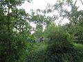
480 feet from where I parked my truck.
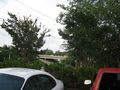
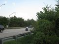
The bridge in the distance is GA400.
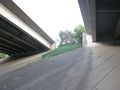
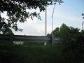
I am now underneath GA400 looking up to the gap between the highway.
51 feet to go from the top of the bridge in between the gap.
Looking at the northbound lane of traffic of GA400 standing at the top of the bridge.
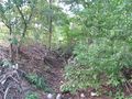
10 feet to go. Close enough.
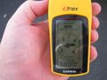
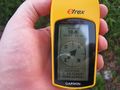
Time of the meetup.
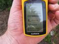
Date of the meetup.
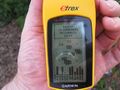
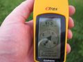
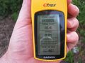
16 feet accuracy. I'm well within the 10 meters.
A look at the Southbound lane of GA400, standing on the Geohash spot.
Northbound lane of traffic with me standing on the Geohash spot.
Looking North standing on the Geohash spot.
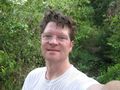
Me, with a Stupid Grin™ standing on the Geohash spot with the camera looking South.


