Difference between revisions of "2011-08-08 57 15"
imported>Fasanen |
imported>Fasanen (Fleshed out) |
||
| Line 1: | Line 1: | ||
| − | |||
| − | |||
| − | |||
| − | |||
| − | |||
| − | |||
| − | |||
| − | |||
| − | |||
{{meetup graticule | {{meetup graticule | ||
| lat=57 | | lat=57 | ||
| Line 14: | Line 5: | ||
}} | }} | ||
| − | |||
__NOTOC__ | __NOTOC__ | ||
== Location == | == Location == | ||
| − | + | Dense forest, SE Stenberga, Småland, Sweden | |
== Participants == | == Participants == | ||
| − | + | * [[User:Fasanen|Fasanen]] | |
| − | |||
| − | |||
| − | |||
== Expedition == | == Expedition == | ||
| − | + | *Sucess in new graticule! -- [[User:Fasanen|Fasanen]] [http://www.openstreetmap.org/?lat=57.31521961&lon=15.57867263&zoom=16&layers=B000FTF @57,3152,15,5787] 11:30, 8 August 2011 (EDT) | |
| + | On my first day of vacation I was to drive 300 km to our small cottage in Virserum which is in the graticule of Vetlanda (57 15). The normal route there for me is driving road 23, but I noticed that if turning north in Åseda and driving small forest roads up to Stenberga, I would get to explore “white spots” on my map and at the same time get a shot at a virgin geohash. | ||
| − | + | After turning in Åseda and some confusion about which small gravel roads to drive I finally got to a position between Stenberga and Björnöström where there were “only” 200 meters to walk to the geohash. This was one of the most unpleasant 200 meters I have ever walked; down a ravine with thorny raspberry bushes, through a treacherous swamp and finally through an almost impenetrable spruce forest. There was a mild smell of cadaver in the air when I finally got a decent GPS reading in a clearing. | |
| − | |||
| − | |||
| − | + | Although the spot was not to be proposed to the local tourist board, I documented some tender flowers and was happy about being the first one to explore Vetlanda. | |
| − | |||
| − | |||
| − | |||
| − | |||
| + | I found a slightly easier way back and got to the cottage where I spent one week repairing the roof. | ||
| + | == Photos == | ||
| + | <gallery perrow="3"> | ||
| + | Image:201108085715 01.JPG |In the thick of it | ||
| + | Image:201108085715 02.JPG |Tender flower I | ||
| + | Image:201108085715 03.JPG |Tender flower II | ||
| + | Image:201108085715 04.JPG |The geohash clearing | ||
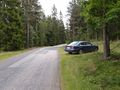
| + | Image:201108085715 05.JPG |The wheels parked 200 meters from geohash | ||
| + | Image:201108085715 06.JPG |Grin | ||
| + | Image:201108085715 07.png |Proof | ||
</gallery> | </gallery> | ||
== Achievements == | == Achievements == | ||
{{#vardefine:ribbonwidth|800px}} | {{#vardefine:ribbonwidth|800px}} | ||
| − | + | {{land geohash | latitude=57 | longitude=15 | date=2011-08-08 | name=Fasanen}} | |
| − | + | {{Virgin graticule | latitude = 57 | longitude = 15 | date = 2011-08-08| name = [[User:Fasanen|Fasanen]]}} | |
| − | |||
| − | |||
| − | |||
| − | [[ | ||
| − | |||
| − | |||
| − | |||
| − | |||
| − | |||
| − | |||
[[Category:Expeditions]] | [[Category:Expeditions]] | ||
| − | |||
[[Category:Expeditions with photos]] | [[Category:Expeditions with photos]] | ||
| − | |||
| − | |||
| − | |||
| − | |||
| − | |||
[[Category:Coordinates reached]] | [[Category:Coordinates reached]] | ||
| − | + | [[Category:Sweden]] | |
| − | |||
| − | |||
| − | |||
| − | |||
| − | |||
| − | |||
| − | |||
| − | [[Category: | ||
| − | |||
Revision as of 19:55, 14 August 2011
| Mon 8 Aug 2011 in 57,15: 57.3091014, 15.4535467 geohashing.info google osm bing/os kml crox |
Location
Dense forest, SE Stenberga, Småland, Sweden
Participants
Expedition
- Sucess in new graticule! -- Fasanen @57,3152,15,5787 11:30, 8 August 2011 (EDT)
On my first day of vacation I was to drive 300 km to our small cottage in Virserum which is in the graticule of Vetlanda (57 15). The normal route there for me is driving road 23, but I noticed that if turning north in Åseda and driving small forest roads up to Stenberga, I would get to explore “white spots” on my map and at the same time get a shot at a virgin geohash.
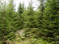
After turning in Åseda and some confusion about which small gravel roads to drive I finally got to a position between Stenberga and Björnöström where there were “only” 200 meters to walk to the geohash. This was one of the most unpleasant 200 meters I have ever walked; down a ravine with thorny raspberry bushes, through a treacherous swamp and finally through an almost impenetrable spruce forest. There was a mild smell of cadaver in the air when I finally got a decent GPS reading in a clearing.
Although the spot was not to be proposed to the local tourist board, I documented some tender flowers and was happy about being the first one to explore Vetlanda.
I found a slightly easier way back and got to the cottage where I spent one week repairing the roof.
Photos
In the thick of it
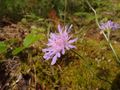
Tender flower I
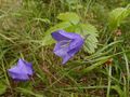
Tender flower II
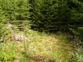
The geohash clearing
The wheels parked 200 meters from geohash

Grin
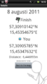
Proof


Achievements
Fasanen earned the Land geohash achievement
|