Difference between revisions of "2011-10-12 40 -74"
From Geohashing
imported>Jevanyn ([live picture] Standing under this tree to try to stay dry (it didn't work) [http://www.openstreetmap.org/?lat=40.70251936&lon=-74.31966313&zoom=16&layers=B000FTF @40.7025,-74.3197]) |
imported>Jevanyn ([live picture] Me and Mr. Bush [http://www.openstreetmap.org/?lat=40.70252015&lon=-74.31965987&zoom=16&layers=B000FTF @40.7025,-74.3197]) |
||
| Line 45: | Line 45: | ||
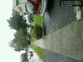
Image:2011-10-12_40_-74_17-23-02-445.jpg | Standing under this tree to try to stay dry (it didn't work) [http://www.openstreetmap.org/?lat=40.70251936&lon=-74.31966313&zoom=16&layers=B000FTF @40.7025,-74.3197] | Image:2011-10-12_40_-74_17-23-02-445.jpg | Standing under this tree to try to stay dry (it didn't work) [http://www.openstreetmap.org/?lat=40.70251936&lon=-74.31966313&zoom=16&layers=B000FTF @40.7025,-74.3197] | ||
| + | |||
| + | Image:2011-10-12_40_-74_17-23-52-358.jpg | Me and Mr. Bush [http://www.openstreetmap.org/?lat=40.70252015&lon=-74.31965987&zoom=16&layers=B000FTF @40.7025,-74.3197] | ||
</gallery> | </gallery> | ||
Revision as of 21:24, 12 October 2011
| Wed 12 Oct 2011 in 40,-74: 40.7024872, -74.3197296 geohashing.info google osm bing/os kml crox |
Location
Springfield, NJ - On Mountain Ave. 3 houses NE of where it crosses Shunpike Rd. - Spindizzy
Participants
Plans
Looks worthy of a No Batteries attempt for me. The hash appears to be in the middle of a tree near a sidewalk. Won't be able to do a meetup, however, due to a prior commitment. - Spindizzy 13:43, 12 October 2011
Expedition
- Wow, really? That's less than a mile from where I work. Be there around 5PM. -- Jevanyn @40.6886,-74.3162 13:00, 12 October 2011 (EDT)
Tracklog
Photos
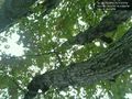
Bush at the hashpoint @40.7025,-74.3197
Standing under this tree to try to stay dry (it didn't work) @40.7025,-74.3197
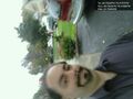
Me and Mr. Bush @40.7025,-74.3197


Achievements