Difference between revisions of "2011-10-28 48 9"
From Geohashing
imported>Ekorren (Been there. Report might be done later.) |
imported>Ekorren (→Gallery) |
||
| Line 17: | Line 17: | ||
== Expedition== | == Expedition== | ||
| − | to | + | Went by bike. Is there so much more to say? ;) |
== Gallery == | == Gallery == | ||
<gallery> | <gallery> | ||
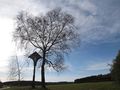
| + | File:2011-10-28_48_9_way_1.JPG|Random impressions along the way | ||
| + | File:2011-10-28_48_9_Oeschingen_Mountain.JPG | ||
| + | File:2011-10-28_48_9_oldhash.JPG|Revisiting an old hash | ||
| + | File:2011-10-28_48_9_way_2.JPG | ||
| + | File:2011-10-28_48_9_way_3.JPG | ||
| + | File:2011-10-28_48_9_Kalkstein_1.JPG | ||
| + | File:2011-10-28_48_9_Kalkstein_2.JPG | ||
| + | File:2011-10-28_48_9_Flora.JPG | ||
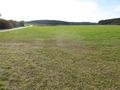
| + | File:2011-10-28_48_9_Hashpoint.JPG|Hashpoint | ||
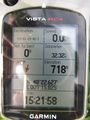
| + | File:2011-10-28_48_9_GPS.JPG|Coordinates reached | ||
| + | File:2011-10-28_48_9_VFH_1.JPG|View from hash | ||
| + | File:2011-10-28_48_9_VFH_2.JPG|View from hash | ||
| + | File:2011-10-28_48_9_cross.JPG|View into direction of the hash from about 50m away | ||
| + | File:2011-10-28_48_9_Lichtenstein.JPG|Castle Lichtenstein, built after the 1800s novel of the same name. | ||
| + | File:2011-10-28_48_9_Schaenzle_Traifelberg.JPG | ||
| + | File:2011-10-28_48_9_Traifelberg.JPG|Some of rocks seem also to want to go down into the valley | ||
</gallery> | </gallery> | ||
Revision as of 17:54, 4 November 2011
| Fri 28 Oct 2011 in 48,9: 48.3771183, 9.2637593 geohashing.info google osm bing/os kml crox |
Contents
Location
Outside of Engstingen, a few metres into a meadow.
Nearest bus stops are Trochtelfingen Haid Haidkapelle (1.8 km) and Engstingen Großengstingen Marktplatz (2.2 km). Nearest train station is Haidkapelle. There's one train per day, schooldays only.
Participants
Ekorren was there by bike, for his third hashiversary.
Expedition
Went by bike. Is there so much more to say? ;)
Gallery
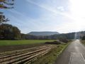
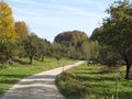
Random impressions along the way
Revisiting an old hash
Hashpoint
Coordinates reached
View from hash
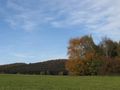
View from hash
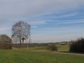
View into direction of the hash from about 50m away
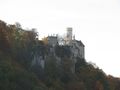
Castle Lichtenstein, built after the 1800s novel of the same name.
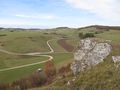
Some of rocks seem also to want to go down into the valley


